 Direct to Big Muddy
![]()
![]()
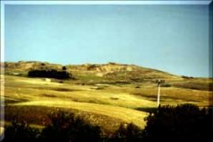
From Radville, leave from the Northwest corner on Highway 377. 7 miles out (11 Kilometers) you will be climbing the Escarpement again. Note to the South side a lobe of ice (likely a squeezed Forward "Flow") has pushed beyond the main mass more than 2 miles (3.5 Kilometers).
Just before you reach Ceylon note the broad valley type land. The hilly moraine material was floated to the southwest when excessive water on the ice broke through and rushed toward the big muddy and drainage to the Missouri River.
A Gap in the moraine allowsGibson Creek waters to flow towards Radville and join with Long Creek, Souris River, on through North Dakota back into Canada and draining through Winnipeg on into Hudson's Bay.
Upon Reaching Highway 6 you may want to see a fieldstone house mentioned in Big Muddy Area Via The Gap. To Continue travel 6 Miles (10 Kilometers) South. The 705 Grid Road crossing is the Convergence Point of the alternate routes.
From the Convergence Point on Number 6 Highway, Grid 705, travel West on a gravel road 8 Miles (13 Kilometers).
Between the third and fourth mile travelled you will note the leveled land from the rush of water and moraine material previously mentioned.
At the eight mile crossroad drive south. This gravel road will lead you through The Hole in The Wall Coulee and cross over to the Roan Mare Coulee.
Both of these Coulees are very old and scenic with their sandstone outcrops, exposed and layered soils.
Watch in the ditch for more layering of coal and mineral bearing soils.
Both of these Coulee's carried great amount's of glacial meltwater toward Big Muddy lake on a temporary basis.
Both are a little more than 300 feet (100 meters) deep and less than a mile wide.
