W
ALKING
T
OUR OF
F
ORT
V
ICTORIA
KEY
-
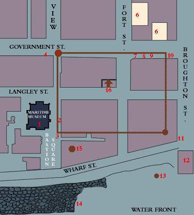
The Supreme Courthouse of British Columbia from 1889 to 1962. It is the oldest surviving Courthouse in the province. Built by Munich-born Herman Tiedemann for the cost of $35,075, it was the first concrete building in British Columbia. It was here too tha
t Chief Justice Matthew Baillie Begbie made his mark.
Top of page
To see a present day photo of this location, click here.
-
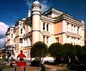
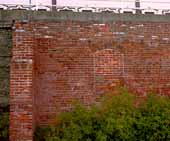
Watch your feet! It is here that most people step back in time without
being aware of it. Just what does this funny row of bricks mean? Set into the brickwork is a handsome outline of Fort Victoria. Fort Victoria, named after Queen Victoria,
was established in 1843 as a Hundon's Bay Company fort under the auspices of Sir James Douglas. In 1858 gold was discovered in the Frasier river and the Rush was on! Hordes of would-be millionaires poured through Victoria on
their way to dreams of gold and glory. In the space of 20 years this
site was transformed from mud and wood to that of carved stone and brick.
Top of page
To see a present day photo of this location, click here.
-
This 'Weeping Camperdown Elm' is more than just a stately tree in Bastion
Square; it is also known as 'The Century Tree' as it was first planted in
1890 at corner of Chambers & Grant streets. It was moved to its current location in 1966.
Top of page
-
Lurking on the side of the former Bank of Montreal building, built by Rattenbury, is a bronze plaque commemorating the year 1986 when the outlines of the northeast bastion of the fort were established. The Hudson's Bay Co. seal is outlined by bricks insc
ribed with the names of its early employees and First Nations representatives.
Top of page
To see a present day photo of this location, click here.
-
On this building there is yet another bronze tablet detailing the northeast bastion, but this time with a picture of the bastion. The tablet itself is of interest as it was cast in 1928.
Top of page
To see a present day photo of this location, click here.
-
It is difficult to imagine when one is looking at the Metro store, that it was the site of two gardens. They were the gardens of Reverend Staine and the Hudson's Bay employees respectively.
Top of page
-
The aforementioned Reverend makes his appearance again, at the location of the first school, now cleverly disguised at the 'Spirit of Christmas' store. It was in 1849, that the R.J. Staine & Wife school opened up. Here too, the first legislative assem
bly met on Aug. 12, 1856.
Top of page
To see a present day photo of this location, click here.
-
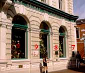
Now behind you and set into the cobbles are two fine seals of the city and the province. Don't worry there is a plaque telling all the details. The plaque is just below the number eight on the photograph.
Top of page
To see a present day photo of this location, click here.
-
What was built on the site of the school and would later become the
'Spirit of Christmas' store was the Canadian Imperial Bank of Commerce.
Established on April 19th, 1886 it was meant to deliver a clear message of wealth and security. This building has an orn
amental facade that has been preserved. The front of the building is made of cast iron. One other note. Robert Service, a famous poet, used to work there. The plaque is just below the number nine on the photograph.
Top of page
To see a present day photo of this location, click here.
-
Now, following the bricks that outline the fort probably meant that you ended climbing over some tea drinkers near Murchies.... but, what is this? The bricks suddenly turn into a jewelry store? Now you are at the northwest corner of the Fort.
Top of page
-
As you make your way down Broughton Street you are going to just have to imagine the location of the southwest corner of the Fort as it is hidden away in the middle of some buildings. Fear not, you can quite happily imagine the cannon at the southwest ba
stion booming its greeting to ships arriving into the harbour.
Top of page
To see a present day photo of this location, click here.
-
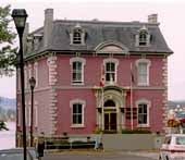
At the end of Broughton Street there to greet you is the 'Malahat Building' looking rather special all done up in pink and sitting just so on the waterfront. It is not just there for the good view.
As it was the 'Customs House' it was often the first thing new arrivals saw.
Top of page
To see a present day photo of this location, click here.
-
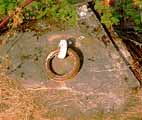
The Mooring Rings at your feet is where the ships would tie up. All of the busy parking lot below was once just mud.
Top of page
To see a present day photo of this location, click here.
-
As you dodge cars in the parking lot, look to the stone walls. Now you are below the level of Wharf Street. You can see doors and pipes set into the stone and brick wall. Sights of underground tunnels and resultant skulking abound.
Top of page
To see a present day photo of this location, click here.
-
Just where do those pipes lead to? The Rithert building holds the clue. In lobby of the 'Small Business & Tourism' building is an amazing discovery. The original well of Fort Victoria sits in the lobby. By the 1870's the well had been forgotten and c
overed over. So completely forgotten, it was quite the shock when it was rediscovered during the restoration of the Rithert building in the 1970's.
Top of page
To see a present day photo of this location, click here.
-
This is the approximate site of the fort's bell tower.
Top of page
To see a present day photo of this location, click here.
 Return to the fort


![[English]](../simages/english.gif)

![[French]](../simages/french.gif)

![[Credits]](../simages/credit.gif)

![[Feedback]](../simages/feedback.gif)