|
Caribou on the Move
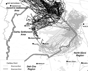 This
map of caribou migration patterns over the past five
years is the product of a satellite collaring program
initiated by DRWED in 1996. The project was a model
of cooperative management, with the support and involvement
of aboriginal representatives. It was co-funded by the
Inuvialuit Land Claim Implementation funds, Gwich’in
Renewable Resource Board, Sahtu Renewable Resources
Board, and the Nunavut Wildlife Management Board. The
project leaders were RWED biologists John Nagy and Alasdair
Veitch. This
map of caribou migration patterns over the past five
years is the product of a satellite collaring program
initiated by DRWED in 1996. The project was a model
of cooperative management, with the support and involvement
of aboriginal representatives. It was co-funded by the
Inuvialuit Land Claim Implementation funds, Gwich’in
Renewable Resource Board, Sahtu Renewable Resources
Board, and the Nunavut Wildlife Management Board. The
project leaders were RWED biologists John Nagy and Alasdair
Veitch.
By mapping migration patterns and studying the genetics
of samples from caribou antlers that have been dropped
by cows on calving grounds, scientists have confirmed
the existence of three separate herds in the northwest
mainland of the Northwest Territories and Nunavut. These
are known in English as the Bluenose-East, Bluenose-West,
and Cape Bathurst herds. This map shows the two herds
that migrate through the Sahtu Region.
Having sorted out the existence of the three herds,
it now becomes possible to get population estimates and
other information specific to each herd. Along with traditional
knowledge about caribou, this information will assist
in monitoring the health of the herds over the long term.
This
article originally appeared in the Mackenzie Valley
Viewer in March, 2001.
|