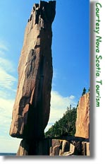
Balancing Rock Trail
(hiking)
 Location: Take Exit 26 off highway 101
at Digby and follow the signs to Digby Neck (highway
217). Take the highway to the end of Digby Neck (East
Ferry). At East Ferry, take the ferry to Tiverton on
Long Island. The ferry costs $2.00 (round trip) and
leaves East Ferry on the half-hour and returns from Tiverton on the hour. Go left when leaving
the ferry and pass through the town of Tiverton. The
trail to the Balancing Rock is approximately 4 km from
the ferry and is marked with a sign on the left-hand
side of the road. Washrooms are located on site.
Location: Take Exit 26 off highway 101
at Digby and follow the signs to Digby Neck (highway
217). Take the highway to the end of Digby Neck (East
Ferry). At East Ferry, take the ferry to Tiverton on
Long Island. The ferry costs $2.00 (round trip) and
leaves East Ferry on the half-hour and returns from Tiverton on the hour. Go left when leaving
the ferry and pass through the town of Tiverton. The
trail to the Balancing Rock is approximately 4 km from
the ferry and is marked with a sign on the left-hand
side of the road. Washrooms are located on site.
The trail is 2.4 km in length
and leads to one of the most photographed and
recognizable landmarks in Nova Scotia. Originally,
the trail was little more than a goat path. It has
since been upgraded and is fully maintained and
groomed. The trail passes through a softwood forest
and a boardwalk takes you across a marsh with some
interesting plant life. At the end of the trail there
is a steep staircase which leads down to the
balancing rock and a rest station. It should be noted
that the last part of this trail is quite strenuous
and those with heart conditions should exercise
caution.
Kejimkujik National
Park (hiking/biking)
Location: Kejimkujik National
is located at Maitland Bridge. Take highway 8 from
Annapolis Royal. There are numerous signs along the
way, you will see a large sign on the right hand side
(west side) marking the entrance.
Kejimkujik National Park was
founded in 1967 in an area that was once a hunting
and fishing retreat. The park has a variety of
vegetation and geography and is home to various
animals and birds. While Kejimkujik is famous for its
canoeing there are also excellent hiking trails. There
are 16 day hikes which range in distance from 0.3 km
to 18 km (return), There are two fully wheelchair
accessible trails and one which has a wheelchair
accessible portion. Some trails take you through 300-year-old hemlock forest,
while another takes you back in time to when gold was
mined here. Some trails are for both hiking and
biking, while others are restricted to hikers only.
The roadways of Kejimkujik make for great biking,
especially in the fall when the foliage colours are
at their peak. Free trail guides detailing all the
day hikes and trail uses can be picked up at the park
information centre when entering the park and for
those wishing to do the overnight hikes a back-country guide purchased from the information centre
is essential. These trails are rocky and narrow in spots
and can be wet depending on the season.
through 300-year-old hemlock forest,
while another takes you back in time to when gold was
mined here. Some trails are for both hiking and
biking, while others are restricted to hikers only.
The roadways of Kejimkujik make for great biking,
especially in the fall when the foliage colours are
at their peak. Free trail guides detailing all the
day hikes and trail uses can be picked up at the park
information centre when entering the park and for
those wishing to do the overnight hikes a back-country guide purchased from the information centre
is essential. These trails are rocky and narrow in spots
and can be wet depending on the season.
For the more adventurous or
those just craving solitude, the park has three
designated overnight hikes. All of these trail start
at the Big Dam Parking Lot. The first and longest of
these is the Liberty Lake trail. This trail is 65 km
in length and has three campsites, which splits the
distance into hikes of 12 km, 16 km, 19 km and 18 km.
While it is possible to do this hike in three nights
and two days, most find that a five-day trip allows
them to enjoy more of the beauty. This trail also
features four side trips, the first with a campsite
is 20 km (return) while the other three are 14 km, 13 km
and 6 km (return).
Channel Lake Trail is a 26 km
loop with two campsites that break the trip into 3
hikes of 5 km, 8 km, and 13 km. It should be noted that
to complete the loop you must pass through Still
Brook. While this is easy during the summer months,
the brook is not passable during the spring. We recommend you ask park staff about the water levels.
The third hike is Big
Dam/Frozen Ocean Trail. This trail is 20 km (return)
or 23 km if you take the first half of the Channel
Lake trail back rather than retrace your footsteps.
This trail is made up of the first 10 km of the
Liberty Lake trail and is a good overnight trip as
there are four campsites along this route.
The back-country trails
provide solitude and a great opportunity for those
who are quiet and have keen eyes for Bob cats, owls,
hawks, turtles, beavers and deer. While Kejimkujik is
also home to black bears, people rarely encounter them
due to their shy and wary nature. While these bears
tend to avoid humans, proper measures should be taken
when in the back-country, especially when dealing with
food.
For more information contact
Kejimkujik National Park
Maitland Bridge, NS
B0T 1N0
Phone: (902) 682-2772
Central Grove Trail
(hiking)
Location: Take Exit 26 off
highway 101 at Digby and follow the signs to Digby
Neck and highway 217. Take highway 217 to East Ferry
and catch the ferry to Tiverton on Long Island
(see Balancing Rock description for rates and
departure times). Leaving the ferry, keep on highway
217 and look for a sign on the right-hand side of the
road for Central Grove Provincial Park. The trail
begins at the back loop of the Provincial Park.
This is a maintained trail
and has picnic tables and outhouses available at the
park. The trail is 1.6 km in length and winds its way
over rocky terrain. It passes through a spruce and
some maple forest. There are bogs with boardwalks
passing over them. The trail ends at a rocky beach
and is a good place to see birds.
Acacia Valley Trail
(hiking/wheelchair accessible)
Location: Near Acaciaville on
route 303 from Digby
The Acacia Valley trail is
presently under construction and is expected to be
open in the spring of 2000. The trail demonstrates
this area's belief that the outdoors are for
everyone. There will be three trails: a novice hiking
and interpretative trail, an advanced trail with
back-country campsites, and a boardwalk loop,
complete with wheelchair accessible fishing
platforms. The Digby East Fish and Game Association
are developing the trail, while working to restore
fish habitat and populations of the Acacia brook
system.
Delap's Cove Wilderness
Trail (hiking & biking)
Location: From Annapolis take
highway 1 across the Annapolis River to Granville
Ferry. At Granville Ferry turn left onto Parker's
Cove Road. Heading towards the Bay of Fundy you will
come to an intersection at the shoreline. Turn left
at the intersection and this will take you to Delap's
Cove. You continue straight until the pavement ends
approximately 22 km from Annapolis Royal. Follow the
signs to the parking lot.
Delap's Cove was settled by
approximately 500 Black Loyalists fleeing the United
States after the American Revolution. However, due to
the rocky nature of the soil and its exposure to the
harsh weather, by 1871 the population was down to
just 70 people. Today all that remains are the
foundations of this past settlement. There are three
trails to choose from: Bohaker, a 2.2 km loop;
Charlie's Loop, a 1.8 km loop; and Shore Road, 2.7 km
(one way), which runs between the two. There is an
interpretative sign at the front of the trail with a
map and washroom facilities are located at the
parking lot. This trail is also used by ATVs (All Terrain Vehicles) and by
hunters, so exercise caution.
Bohaker Trail starts by the
interpretative sign and goes down hill to the water and
along the coastline. You will soon come to Bohaker
Brook and the 13m (43ft) Bohaker falls. There is a
great look out at the top of the falls, accessible
from a side trail that leads across the brook.
Continuing on the main trail, you head back inland
and will soon reach a junction with Shore Road. You
can turn left here and head back to your car.
Shore Road Trail is actually
the remains of what used to be a highway running along the North Mountain Range. There are no
visible landmarks along this trail and only a small
sign indicating the entrance to Charlie's Loop, so
watch carefully.
Charlie's Loop is 1.8 km in
distance and has several offshoots to the water. The
first offshoot gives hikers a chance to see a small
vein of agate. The third offshoot has a platform
over-looking Charlie's Cove. The trail then turns
inland back to Shore Road. Keep an eye out here for
the foundations of the old settlement. Once back on
Shore Road, you retrace your steps back to the
parking lot.
Mickey Hill Pocket
Wilderness (hiking/biking/skiing)
Location: From Annapolis
Royal go South on highway 8. The trail parking
lot is approximately 10 km from Annapolis Royal you
will see a large sign on the left-hand (east) side of
the road.
The land that makes up the
Mickey Hill Pocket Wilderness belongs to Bowater
Mersey Paper Company Ltd. There is a map of the trail
posted at the parking lot and the 2-km (return) gravel
trail has a picnic area and freshwater beach. There
are interpretative sites and a boardwalk through a
marsh as well as a suspension bridge and a treetop
lookout. The trail intersects with an excavated road
that provides an added 4 km (one-way) of trails.
PUBLICATIONS
& RESOURCES
Land Registration &
Information Service (maps)
396 Main Street
Lawrencetown, NS
B0S 1M0
Tel: (902) 584-2266Nimbus Publishing
1-800-646-2879
PO Box 9301, Station A
Halifax, NS
B3K 5N5
In Forest
and Field
J.S.
Erkstine
Nova
Scotia Museum
Nova
Scotia Nature Map
Nova
Scotia Museum
A Map of
the Province of Nova Scotia
Province
of Nova Scotia & Formac Publishing
(a book
of 45 1:250 000 scale maps)
Belliveau
Cove Eco-Tours
RR1 PO Box 83
Church Point, NS
B0W 1M0
Tel: (902) 837-1056
Milford
House
PO Box 521
Annapolis Royal, NS
B0S 1A0
Tel: (902) 532-2671
Natural
History of Nova Scotia
Vol 1
& 2
Nimbus/Nova
Scotia Museum
Walk
on the Wildside Nature Tours
Westport, Brier Island, NS
B0V 1H0
Tel: (902) 839-2962
Sou'Wester
Adventure Tours
(Canoe, bicycle, specialty tours)
P.O. Box 22
Bridgetown, NS
B0S 1C0
Tel: (902) 665-4004
Nova
Scotia Trails Federation
5516 Spring Garden Rd
P.O. Box 3010, Halifax, NS
B3J 3G6
Tel: (902) 425-5450 ext. 325
Fax: (902) 425-5606
Kejimkujik
National Park
P.O. Box 236,
Maitland Bridge, NS
B0E 2W0
Tel: (902) 682-2772
|
Nova Scotia Government
Bookstore
1700 Granville St.
PO Box 637
Halifax, NS
B3J 2T3
Tel: (902) 424-7580
Online CatalogueHiking Trails of
Nova Scotia
Michael Haynes
Goose Lane Editions
469 King Street, NB
E3B 1E5
Biking To
Blissville
Kent Thompson
Goose Lane
Wildlife
of Nova Scotia
Julie
Towers
Dept of
Natural Resources
Summer
Nature Notes
Merrit
Gibson
Dept.
Natural Resources
(Has a list of licensed guides)
PO Box 130
Lawrencetown, NS
B0S 1N0
Tel: (902) 584-2229
Annapolis
River Campground
50 Queen Street
Bridgetown, NS
B0S 1C0
Tel: (902) 665-2801
Hinterland
Adventures And Gear
54 Gates Lane
Weymouth, NS
B0W 3T0
Tel: (902) 837-4092
Fax: (902) 837-5196
Odysseys@isisnet.com
Brev
Adventures
(Bicycle tours)
22 School St.
P.O. Box 76
Middleton, NS
B0S 1P0
(902) 825-2564
Belliveau
Cove Eco Tours
Belliveau Cove, Digby Co, NS
B0W 1M0
Phone: (902)837-1056
Phone: (902)769-7899
Annapolis
County Recreation Dept
P.O. Box 100
Annapolis Royal, NS
B0S 1A0
Tel: (902) 532-2331

|