Île du Prince-Édouard, 1765 - Exploration - Le Canada à l'échelle : les cartes de notre histoire - Expositions - Bibliothèque et Archives Canada
 Bibliothèque et Archives Canada - Library and Archive Canada English | Aide     Canada  
 Page d'accueil > Explorer les thèmes choisis > Le Canada à l'échelle > Exploration
  Avis importants  
Exploration, colonisation et développement

Allez-y

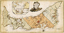
Île du Prince-Édouard, 1765

L’île fut la première des nouvelles colonies anglaises pour laquelle un arpentage général fut fait. Samuel Holland en eut la responsabilité. L’île Saint-Jean du temps des Français, île Saint John après, elle ne prendra son nom actuel qu’en 1799.

Holland conçut aussi un système d’arpentage des terres du Bas et du Haut-Canada.

Notice catalographique :
Holland, Samuel, 1728-1801.
A plan of the island of St. John : with the divisions of the counties, parishes & the lots granted by government likewise the soundings round the coast and harbours / surveyed by Capt. Holland. — Échelle [env. 1:253 440]. — [London] : Sold by M. A. Roque ... : Jefferys & Faden ... , 1765. — 1 carte : coloriée à la main ; 36 x 70 cm, sur feuille 46 x 74 cm. —

No de réf. : NMC 023350

023350k

Précédente   Suivante Retour au Canada À l`Échelle