Prince Edward Island, 1765 - Exploration - Canada at Scale: Maps of our History - Exhibitions - Library and Archives Canada
 Library and Archive Canada - Bibliothèque et Archives Canada Français | Help     Canada  
 Home > Browse Selected Topics > Canada at Scale > Exploration
  Important Notices  
Exploration, colonization and development

GO

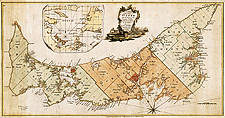
Prince Edward Island, 1765

The island was the first of the new English colonies for which a general survey was conducted. Samuel Holland was in charge of the survey. Known as Île Saint-Jean at the time of the French, and later Saint John Island, it did not take its present name until 1799.

Holland also designed a system for surveying lands in Upper and Lower Canada.

Catalogue entry:
Holland, Samuel, 1728-1801.
A plan of the island of St. John : with the divisions of the counties, parishes & the lots granted by government likewise the soundings round the coast and harbours / surveyed by Capt. Holland. — Scale [ca. 1:253 440]. — [London] : Sold by M. A. Roque ... : Jefferys & Faden ... , 1765. — 1 map : hand col. ; 36 x 70 cm, on sheet 46 x 74 cm. —

Ref. No.: NMC 23350

n023350k

Previous   Next Return to Canada at Scale