Le littoral du Pacifique de l’Amérique du Nord, 1798 - Exploration - Le Canada à l'échelle - Expositions - Bibliothèque et Archives Canada
 Bibliothèque et Archives Canada - Library and Archive Canada English | Aide     Canada  
 Page d'accueil > Explorer les thèmes choisis > Le Canada à l'échelle > Exploration
  Avis importants  
Exploration, colonisation et développement

Allez-y

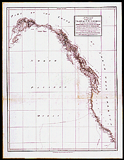
Le littoral du Pacifique de l’Amérique du Nord, 1798

George Vancouver a fait un relevé de la côte nord-ouest de l’Amérique de 1792 à 1795. Dans son journal et ses cartes, il rejette la possibilité de l’existence d’un passage du Nord-Ouest débouchant sur cette côte.

Notice catalographique :
Vancouver, George, 1757-1798.
A chart shewing part of the coast of N.W. America : with the tracks of His Majesty’s sloop Discovery and armed tender Chatham commanded by George Vancouver Esqr. and prepared from the foregoing surveys under his immediate inspection by Lieut. Edwd. Roberts in which the continental shore has been correctly traced and determined from lat. 29°54' N and long 244° 33' E to Cape Douglas in lat. 58°52' N and long 207°20' E during the summers of 1792, 1793 and 1794. — Échelle [env. 1:6 500 000]. — London : J. Edwards ... & G. Robinson..., May 1st 1798. — 1 carte ; 75 x 58 cm, sur feuille 85 x 66 cm. — Feuille 14 d’un atlas de f. mobiles accompagnant Voyage of discovery to the North Pacific Ocean publié par Vancouver en 1798. —

No de réf. : NMC 135094

n135094k

Précédente   Suivante Retour au Canada À l`Échelle