The Pacific Coast of North America, 1798 - Exploration - Canada at Scale: Maps of our History - Exhibitions - Library and Archives Canada
 Library and Archive Canada - Bibliothèque et Archives Canada Français | Help     Canada  
 Home > Browse Selected Topics > Canada at Scale > Exploration
  Important Notices  
Exploration, colonization and development

GO

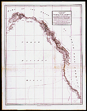
The Pacific Coast of North America, 1798

George Vancouver carried out a survey of the northwest coast of North America between 1792 and 1795. In his logbook and charts, he dismissed the possibility of a northwest passage ending along that coastline. He also produced detailed charts of portions of the coast.

Catalogue entry:
Vancouver, George, 1757-1798.
A chart showing part of the coast of N.W. America : with the tracks of His Majesty’s sloop Discovery and armed tender Chatham commanded by George Vancouver Esqr. and prepared from the foregoing surveys under his immediate inspection by Lieut. Edwd. Roberts in which the continental shore has been correctly traced and determined from lat. 29°54' N and long 244° 33' E to Cape Douglas in lat. 58°52' N and long 207°20' E during the summers of 1792, 1793 and 1794. — Scale [ca. 1:6 500 000]. — London : J. Edwards ... & G. Robinson..., May 1st 1798. — 1 map ; 75 x 58 cm, on sheet 85 x 66 cm. — Sheet 14 of a loose-leaf atlas accompanying Vancouver’s Voyage of discovery to the North Pacific Ocean published in 1798. —

Ref. No.: NMC 135094

n135094k


Previous   Next Return to Canada at Scale