New France by Guillaume De l’Isle, 1741 - Exploration - Canada at Scale: Maps of our History - Exhibitions - Library and Archives Canada
 Library and Archive Canada - Bibliothèque et Archives Canada Français | Help     Canada  
 Home > Browse Selected Topics > Canada at Scale > Exploration
  Important Notices  
Exploration, colonization and development

GO

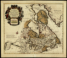
New France by Guillaume De l’Isle, 1741

A fine summary of French explorations, the map first appeared in 1703 and was updated until 1790. It is the first map to show lines of latitude and longitude fairly accurately.

Catalogue entry:
L’Isle, Guillaume de, 1675-1726.
Carte du Canada ou de la Nouvelle France et des decouvertes qui y ont été faites ... / dressée ... par Guillaume De l’isle. — Scale [ca. 1:9 000 000]. — A Amsterdam : Chez Iean Covens et Corneille Mortier, [1730]. — 1 map : hand col. ; 48 x 56 cm, on sheet 63 x 55 cm. — In [Collection des cartes de l’Amérique]. [A Amsterdam : Chez J. Cóvens et C. Mortier, ca. 1741]. —

Ref. No.: NMC 008462

n008462k


Previous   Next Return to Canada at Scale