

|
|
Français | Help |
|
|
Important Notices |
The maps in this section feature the cartography of what was to become Canada, and the directions its development would take. It was difficult to map this country: the land mass is so vast, the climate often very harsh, and the country endured long periods of war. Explorers and cartographers groped along, by trial and error, contradicting each other, sometimes getting lost in obscure theories about North American geography, and only slowly obtained the information gathered by other countries. Nevertheless, navigation techniques, astronomical measurements and the making and printing of maps continued to evolve; the abstract notions gradually disappeared and information began to circulate more widely. The maps showing Canada and its surrounding waters quickly became more accurate and more reliable. We must also remember that Aboriginal peoples provided a great deal of useful information. By studying maps, we can explore the country’s political, economic and social history. Under first the French and then the English, knowledge continued to progress, first from the East and Northeast, then from the West and the Pacific Coast, and then into the entire Arctic region. The growth of maps produced in Canada, both general and detailed, reached new heights. |
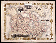 Canada by Tallis |
|