The Maritime Provinces, 1854 - Exploration - Canada at Scale: Maps of our History - Exhibitions - Library and Archives Canada
 Library and Archive Canada - Bibliothèque et Archives Canada Français | Help     Canada  
 Home > Browse Selected Topics > Canada at Scale > Exploration
  Important Notices  
Exploration, colonization and development

GO

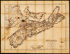
The Maritime Provinces, 1854

This is the third edition of this map published in Pictou, Nova Scotia, by James Dawson & Son. It was one of the first maps printed in Eastern Canada.

Catalogue entry:
Dawson, J. W.
Nova Scotia, Prince Edward Island and part of New Brunswick. — 3rd ed.with many additional names & corr. — Scale [ca. 1:880 000]. — Pictou, N.S. : James Dawson & Son, 1854. — 1 map ; 48 x 63 cm, on sheet 56 x 72 cm. —

Ref. No.: NMC 018093

n018093k

Previous   Next Return to Canada at Scale