Le Saint-Laurent par Jefferys, 1776 - Exploration - Le Canada à l'échelle - Expositions - Bibliothèque et Archives Canada
 Bibliothèque et Archives Canada - Library and Archive Canada English | Aide     Canada  
 Page d'accueil > Explorer les thèmes choisis > Le Canada à l'échelle > Exploration
  Avis importants  
Exploration, colonisation et développement

Allez-y

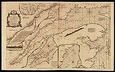
Le Saint-Laurent par Jefferys, 1776

Le fleuve était une artère vitale pour les métropoles et c’est pourquoi Bellin, d’Anville, Cook et d’autres en ont publié de belles cartes. Sur celle-ci, parue en 1757, on remarque des cartons (petites cartes) des bons ports et rades le long du fleuve.

Notice catalographique :
Jefferys, Thomas, 1695?-1771.
An exact chart of the river St. Lawrence, from Fort Frontenac to the Island of Anticosti : shewing the soundings, rocks, shoals &c with views of the lands and all necessary instructions for navigating that river to Quebec ... / Thos. Jefferys. — Échelle [env. 1:729 231]. — London : Printed for Robt. Sayer ..., 25 May, 1775. — 1 carte : coloriée à la main ; 59 x 95 cm. — In The American Atlas, or A geographical description of the whole continent of America ... London : Printed and sold by R. Sayer and J. Bennett, 1776. —

No de réf. : NMC 184117

n184117k

Précédente   Suivante Retour au Canada À l`Échelle