The St. Lawrence by Jefferys, 1776 - Exploration - Canada at Scale: Maps of our History - Exhibitions - Library and Archives Canada
 Library and Archive Canada - Bibliothèque et Archives Canada Français | Help     Canada  
 Home > Browse Selected Topics > Canada at Scale > Exploration
  Important Notices  
Exploration, colonization and development

GO

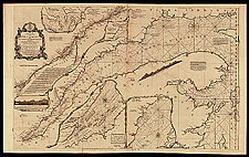
The St. Lawrence by Jefferys, 1776

The St. Lawrence River was a vital artery for the colonial powers, and for this reason, Bellin, d’Anville, Cook and others published attractive charts of it. This particular chart was first published in 1757. In addition to the main chart, there are insets (small charts) of good ports and basins along the river.

Catalogue entry:
Jefferys, Thomas, 1695?-1771.
An exact chart of the river St. Lawrence, from Fort Frontenac to the Island of Anticosti : shewing the soundings, rocks, shoals &c with views of the lands and all necessary instructions for navigating that river to Quebec ... / Thos. Jefferys. — Scale [ca. 1:729 231]. — London : Printed for Robt. Sayer ..., 25 May, 1775. — 1 map : hand col. ; 59 x 95 cm. — In The American Atlas, or A geographical description of the whole continent of America ... London : Printed and sold by R. Sayer and J. Bennett, 1776. —

Ref. No.: NMC 184117

n184117k

Previous   Next Return to Canada at Scale