Montreal region by Bouchette, 1831 - Exploration - Canada at Scale: Maps of our History - Exhibitions - Library and Archives Canada
 Library and Archive Canada - Bibliothèque et Archives Canada Français | Help     Canada  
 Home > Browse Selected Topics > Canada at Scale > Exploration
  Important Notices  
Exploration, colonization and development

GO
n097796-1k n097796-2k
n097796-3k n097796-4k

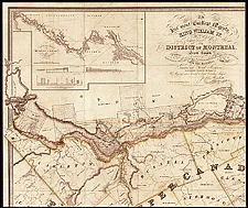
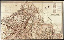
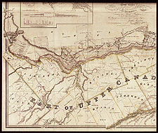
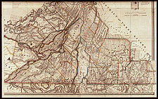
Montreal region by Bouchette, 1831

Bouchette published several detailed maps of Lower Canada (Quebec). This particular map shows the lands in the old French seigneurial system and the new townships. The map was prepared in Canada but published in London because Canada did not yet have the capability to print such maps.

Catalogue entry:
Bouchette, Joseph, 1774-1841.
To His Most Excellent Majesty, King William IV, this topographical map of the district of Montreal, Lower Canada exhibiting the new civil division of the district into counties ... : also a large section of Upper Canada, traversed by the Rideau Canal is ... most humbly & gracefully dedicated / by ... Joseph Bouchette ... and Lieutt. Colonel C.M. ; engraved by J. & C. Walker ... — Scale [ca. 1:152 000]. — London : Published by James Wyld ... , May 2nd, 1831. — 1 map on 2 sheets : hand col. ; 97 x 226 cm, on sheets 101 x 132 cm or smaller — Sheet 2.

Ref. No.: NMC 097796-1, NMC 097796-2, NMC 097796-3, NMC 097796-4


Previous   Next Return to Canada at Scale