Fire insurance plan, Welland, Ontario, Sheet 20, 1916 - Exploration - Canada at Scale: Maps of our History - Exhibitions - Library and Archives Canada
 Library and Archive Canada - Bibliothèque et Archives Canada Français | Help     Canada  
 Home > Browse Selected Topics > Canada at Scale > Exploration
  Important Notices  
Exploration, colonization and development

GO

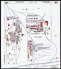
Fire insurance plan, Welland, Ontario, Sheet 20, 1916

These plans were used to assess the risk of fire (colours and symbols indicated the materials used for each building) and the municipality’s firefighting infrastructure. More than 2,000 plans containing more than 40,000 sheets like this one were produced for Canada.

Catalogue entry:
Chas. E. Goad Co.
[Industrial area along Welland Canal]. — Scale [1:1 200]. — [S.l.] : Chas. E. Goad, c1916. — 1 map : col. ; sheet 64 x 54 cm. — In Welland, Ont. : [fire insurance atlas]. Pl. 20. —

Ref. No.: NMC 009766

n009766k

Previous   Next Return to Canada at Scale