La carte de Palliser, 1865 - Exploration - Le Canada à l'échelle : les cartes de notre histoire - Expositions - Bibliothèque et Archives Canada
 Bibliothèque et Archives Canada - Library and Archive Canada English | Aide     Canada  
 Page d'accueil > Explorer les thèmes choisis > Le Canada à l'échelle > Exploration
  Avis importants  
Exploration, colonisation et développement

Allez-y

n183944akn183944bk

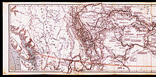
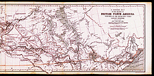
La carte de Palliser, 1865

Les pouvoirs publics avaient envoyé le capitaine Palliser explorer la région entre le lac Supérieur et les Rocheuses entre 1857 et 1860. Le développement de l’Ouest sera, en bonne partie, fondé sur les renseignements fournis par les cartes et le rapport de Palliser, et ceux produits par d’autres expéditions semblables.

Notice catalographique :
Palliser, John, 1807-1887.
A general map of the routes in British North America explored by the expedition under Captain Palliser during the years 1857, 1858, 1859, 1860 : compiled from observations and reports of Captain Palliser and his officers, including the maps constructed by Dr. Hector, and other authentic documents. — Échelle [env. 1:2 200 000]. — London : Standford’s Geographical Estabt., 1865. — 1 carte : coul. ; 34 x 127 cm. — In Index and maps to Captain Palliser’s reports ... London : Printed by George Edward Eyre and William Spottiswoode, 1865. — Accompagne: The journals, detailed reports and observations relative to the exploration, by Captain Palliser of the portion of British North America ... during the years 1857, 1858, 1859, 1860. London : Printed by George Edward Eyre and William Spottiswoode, 1863. —

Nos de réf. : NMC 183944a, 183944b


Précédente   Suivante
Retour au Canada À l`Échelle