Palliser’s map, 1865 - Exploration - Canada at Scale: Maps of our History - Exhibitions - Library and Archives Canada
 Library and Archive Canada - Bibliothèque et Archives Canada Français | Help     Canada  
 Home > Browse Selected Topics > Canada at Scale > Exploration
  Important Notices  
Exploration, colonization and development

GO

n183944akn183944bk

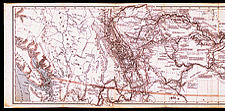
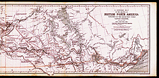
Palliser’s map, 1865

Public authorities sent Captain Palliser to explore the territory from Lake Superior to the Rockies between 1857 and 1860. The development of the West would be largely based on the information provided by Palliser’s maps and reports and those produced by other similar expeditions.

Catalogue entry:
Palliser, John, 1807-1887.
A general map of the routes in British North America explored by the expedition under Captain Palliser during the years 1857, 1858, 1859, 1860 : compiled from observations and reports of Captain Palliser and his officers, including the maps constructed by Dr. Hector, and other authentic documents. — Scale [ca. 1:2 200 000]. — London : Standford’s Geographical Estabt., 1865. — 1 map : col. ; 34 x 127 cm. — In Index and maps to Captain Palliser’s reports ... London : Printed by George Edward Eyre and William Spottiswoode, 1865. — Accompanies: The journals, detailed reports and observations relative to the exploration, by Captain Palliser of the portion of British North America ... during the years 1857, 1858, 1859, 1860. London : Printed by George Edward Eyre and William Spottiswoode, 1863. —

Ref. Nos.: NMC 183944a, 183944b


Previous   Next
Return to Canada at Scale