Province of Manitoba, 1871 - Exploration - Canada at Scale: Maps of our History - Exhibitions - Library and Archives Canada
 Library and Archive Canada - Bibliothèque et Archives Canada Français | Help     Canada  
 Home > Browse Selected Topics > Canada at Scale > Exploration
  Important Notices  
Exploration, colonization and development

GO

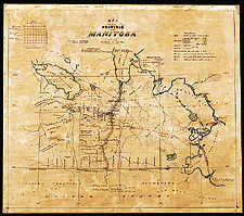
Province of Manitoba, 1871

This is the oldest map of the province of Manitoba, which had just been created. The Métis rebellion had just taken place, and the map shows the juxtaposition of their surveying system and the system of new townships created by the govenment. The prime meridian, the backbone for surveying, is shown west of Pembina on the American border.

Catalogue entry:
Russell, A.L. (Alexander Lord), 1842-1922.
Map of the Province of Manitoba / compiled by A.L. Russell. — Scale [1:633 600]. — Febry. 1871. — 1 map : ms., col., 58 x 66 cm, on sheet 60 x 69 cm. —

Ref. No.: NMC 017551


n017551k

Previous   Next Return to Canada at Scale