Coppermine, 1820-1821 - Exploration - Canada at Scale: Maps of our History - Exhibitions - Library and Archives Canada
 Library and Archive Canada - Bibliothèque et Archives Canada Français | Help     Canada  
 Home > Browse Selected Topics > Canada at Scale > Exploration
  Important Notices  
Exploration, colonization and development

GO

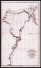
Chart of the Franklin expedition along the Coppermine, 1820-1821

The mere mention of Captain Franklin’s name brings to mind his voyages through the Arctic archipelago in the 1840s. He also spent a great deal of time exploring the Arctic coast of North America and the valleys of the major rivers that flow northward, such as the Coppermine depicted here.

Catalogue entry:
A chart of the discoveries & route of the Northern Land Expedition, under the command of captain Franklin, R.N. in the years 1820 & 2 / laid down under his inspection by the officers assisting in the expedition : J. Walker sculpt. — Scale [ca. 1:910 000]. — London : John Murray, March 1823. — 1 map ; 80 x 47 cm, on sheet 85 x 51 cm. —

Ref. No.: NMC 024319

n024319k


Previous   Next Return to Canada at Scale