Map of Indian reserves, 1891 - Exploration - Canada at Scale: Maps of our History - Exhibitions - Library and Archives Canada
 Library and Archive Canada - Bibliothèque et Archives Canada Français | Help     Canada  
 Home > Browse Selected Topics > Canada at Scale > Exploration
  Important Notices  
Exploration, colonization and development

GO

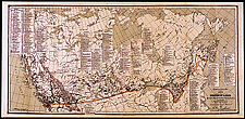
Map of Indian reserves, 1891

Indian reserves have existed in Canada since the time of New France. They were created through a variety of means — by missionaries or private individuals, concession of Crown lands, treaties between Indian bands and the government.

Catalogue entry:
Canada. Dept. of Indian Affairs.
Map of the Dominion of Canada showing Indian reserves. — Scale [ca. 1:250 000]. — [1891?]. — 1 map : col. ; 64 x 139 cm, on sheet 71 x 149 cm. — "To accompany Annual report of 1891. L. Van Koughnet, Deputy Supt. Genl. of Indian Affairs." —

Ref. No.: NMC 117506

n117506k


Previous   Next Return to Canada at Scale