Canada by Tallis, 1851 - Exploration - Canada at Scale: Maps of our History - Exhibitions - Library and Archives Canada
 Library and Archive Canada - Bibliothèque et Archives Canada Français | Help     Canada  
 Home > Browse Selected Topics > Canada at Scale > Exploration
  Important Notices  
Exploration, colonization and development

GO

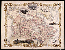
Canada by Tallis, 1851

John Tallis published a number of maps of Canada combining great geographical accuracy with attractive vignettes and borders. This map of Canada is an example of these high quality maps produced to reach a large audience.

Catalogue entry:
Rapkin, J.
British America / map drawn & engraved by J. Rapkin : the illustrations by H. Warren, & engraved by R. Wallis. — Scale [ca. 1:22 000 000]. — London ; New York : John Tallis & Company, [1851]. — 1 map : hand col. ; 22 x 30 cm, on sheet 28 x 37 cm. —

Ref. No.: NMC 141864

n141864k


Previous   Next Return to Canada at Scale