Hydrographic chart of Burrard Inlet, British Columbia, 1900 - Government - Canada at Scale: Maps of our History - Exhibitions - Library and Archives Canada
 Library and Archive Canada - Bibliothèque et Archives Canada Français | Help     Canada  
 Home > Browse Selected Topics > Canada at Scale > Government
  Important Notices  
Government Cartography

GO

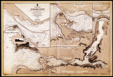
Hydrographic chart of Burrard Inlet, British Columbia, 1900

In 1883, the government began to carry out general hydrographic surveys, and the charts resulting from those surveys were published "by order of the Government of the Dominion of Canada" in the British Admiralty’s series of hydrographic charts. Canada’s own hydrographic service was created in 1904.

Catalogue entry:
Great Britain. Admiralty.
922: Burrard Inlet / surveyed by Mr. W.J. Stewart, under the direction of staff commander J.G. Boulton, R.N., 1891, by order of the government of the Dominion of Canada — Large corr. Aug. 1900. — Scale [ca. 1:36 500]. — London : The Admiralty, [1900]. — 1 map ; 49 x 99 cm, on sheet 68 x 101 cm. — ([British Admiralty charts]). —

Ref. No.: NMC 021045

n021045k

Previous   Next Return to Canada at Scale