Geological map of a portion of central Canada, 1875 - Government - Canada at Scale: Maps of our History - Exhibitions - Library and Archives Canada
 Library and Archive Canada - Bibliothèque et Archives Canada Français | Help     Canada  
 Home > Browse Selected Topics > Canada at Scale > Government
  Important Notices  
Government Cartography

GO

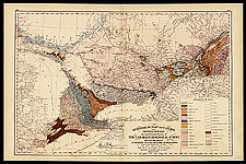
Geological map of a portion of central Canada, 1875, in Walker & Miles atlas, sheets 122-123

This plate gives some idea of the big geological map of Canada produced in 1869, which summarized the first 27 years of work by the Geological Survey of Canada. The 1869 map was the first geological map of the whole country.

Catalogue entry:
Walker & Miles (Firm)
Geological map of Canada and Newfoundland. Sheet no. 3 / derived from the results of the Canadian Geological Survey and from labors of J.W. Dawson, James Robb, J. B. Jukes and others. — Scale 1:158 400. — Montreal ; Toronto : Walker and Miles, 1875. — 1 map : col. ; 41 x 62 cm, on sheet 46 x 70 cm. — In The New standard atlas of the Dominion of Canada : compiled by special permission of the general and provincial governments, from the latest official maps and surveys ... P. 122-123. —

Ref. No.: NMC 080261

n080261k

Previous   Next Return to Canada at Scale