La Vérendrye and Sons (1727-1743)Gaultier de Varennes et de La Vérendrye, Pierre (1685-1749). Journals and Letters of Pierre Gaultier de Varennes de La Vérendrye and His Sons [...] Touching the Search for the Western Sea. Edited by Lawrence J. Burpee. Toronto: The Champlain Society, 1927.
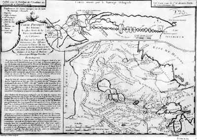
In the early 1720s French explorers still knew relatively little about the interior of the North American continent, since the most western point they had reached at that time was Lac La Pluie (Rainy Lake, Ontario). However, they believed in the existence of a western sea somewhere in the interior of the continent, similar to a gulf and opening onto the Pacific, in something like the way the Gulf of Mexico opens onto the Atlantic. In addition, they thought that it could be reached by a river flowing into the sea. One Canadian, La Vérendrye, made this view his own. Born in Trois Rivières in 1685, Pierre Gaultier de Varennes et de La Vérendrye first served in the army in Canada and Europe (1696-1712) and then devoted himself to farming near Trois Rivières (1712-1727), before being appointed commander at Kaministiquia (Thunder Bay). The information provided by the Indians of North America frequenting this trading post, especially Auchagah, soon convinced him that the way to the Western Sea led through the lakes bordering the prairies. In 1731 La Vérendrye set out to discover the Western Sea, assisted by his four sons: Jean-Baptiste (1713-1736), Pierre (1714-1755), François (1715-1794) and Louis-Joseph (1717-1761). La Vérendrye first went to Lake Winnipeg; then, basing himself on the reports of Indians of North America who described to him a hamlet on the banks of the "Western River", he concentrated his search efforts in a southwesterly direction. It took him eight years to realize that the "Western River" was in reality the Missouri, which led via the Mississippi to the Gulf of Mexico! La Vérendrye resumed his explorations on the Canadian plains and realized that the Saskatchewan River could be a route for an expedition to the Western Sea. But it was too late: La Vérendrye died in 1749, before he could explore this new avenue. In hindsight, and on the continental scale, the contribution of La Vérendrye and his sons to the discovery of North America may appear modest, but at the time nobody suspected the immense distance separating Lake Superior from the Pacific Ocean. By pushing back the frontiers of the known world beyond present-day Manitoba, they provided a glimpse of the immensity to their successors.
| |||||||||||||||||||