|
Yukon Territory
Entered Confederation: 1898
Earliest Peoples
Historical evidence suggests that the area that is now the Yukon Territory was home to the earliest people of North America. They probably travelled from Asia over a land bridge now covered by Bering Strait. There is some disagreement as to exactly when humans were first in the area, but estimates place the date around 11 000 years ago.
At the time of the arrival of the first European explorers to the Yukon, the region was home to such Native peoples as the Dene, the Inland Tlingit, the Gwitch'in, the Han, the Kaska, the Tagish, and the Tutchone. The people lived a mainly nomadic existence, following the migration patterns and natural cycles of food sources such as the caribou. This lifestyle lent itself to small living and travelling groups, although the people did gather in larger numbers at times like the fishing season. In spite of the harsh conditions of living on the land, these early people survived and prospered.
Explorers
The first Europeans to come to the Canadian North were explorers looking for new territory. Martin Frobisher was the first of these, arriving in the eastern Arctic in 1576 on his quest for the Northwest Passage. Other early visitors to the North included John Davis, Thomas Baffin, and Henry Hudson. After the Hudson's Bay Company (HBC) received its charter in 1670 over the territory known as Rupert's Land, men travelled the area seeking new resources for the fur trade. Among them was Samuel Hearne, who mapped the course of the Coppermine River from 1770 to 1772. The North West Company (NWC), formed in the 1780s in Montreal, sent its own men to survey the area beyond Rupert's Land. Of these, the most famous was probably Alexander Mackenzie, who explored the length of the Mackenzie River in 1789.
Still later were the scientific surveyors who came to learn about the Yukon's plant and animal life, as well as its topography. Robert Kennicott, an American working on behalf of the Smithsonian Institute, and later for the Overland Telegraph Company, travelled extensively in the area during the early 1860s. He enlisted the aid of HBC employees in collecting data and samples. In 1883, an expedition led by Frederick Schwatka, an American soldier, travelled through the western part of the Yukon while conducting a survey of Alaska.
Although Canada had acquired its northwestern holdings in 1870, it was not until American expeditions, such as Schwatka's, passed through the area that the Canadian government sent its own explorers. George M. Dawson, the assistant director of the Geological Survey of Canada, led a team through the region in the summer of 1887. He mapped the area, and made scientific observations; if he was unable to explore a certain region personally, he gained knowledge of it by talking to miners who worked there. Another member of the Geological Survey team, William Ogilvie, entered the area through the Chilkoot Pass, and spent most of his time in the Yukon discussing proposed mining policies. Upon his return to Ottawa, however, Ogilvie advised the government that the time was not yet right to assert authority in the Yukon.
Missionaries
Close on the heels of the fur traders and early explorers of the Northwest were the Anglican and Catholic missionaries intent on converting the Native people of the area to Christianity. They established missions near the trading posts of the fur companies, and made extended journeys through the country, in order to reach as many people as possible. One of the most notable missionaries was W. C. Bompas, who came to the region in 1865 and who eventually became the first bishop of the Yukon diocese. While the missionaries did not immediately publish accounts of their travels and observations outside of the church, they too ultimately contributed to the store of knowledge about the region.
The Fur Trade
The fur trade was for many years the most important part of the northern economy, at least for people to the south. Although Native people had long traded with one another, European interest in furs gave the trade a new pattern. Native "middlemen" would bring furs to the trading posts and exchange them for desired goods, which they would then distribute amongst their own people. Both the HBC and the NWC established trading posts throughout the area; after the HBC took over the NWC in 1821, it controlled the fur trade as far west as the Mackenzie Valley.
It was not until the 1840s that the HBC began moving into what is now the Yukon Territory. Robert Campbell, starting from what is now northern British Columbia, travelled as far as the Pelly River in 1839-40. John Bell, also on behalf of the HBC, reached the Yukon River in 1845. Trading posts were established, beginning with Lapierre House in 1846, Fort Youcon in 1847, and Fort Selkirk in 1848 (this last destroyed in 1852). The Yukon region grew in importance, as resources in Rupert's Land became depleted. At the same time, fashionable interest was turning from beaver pelts (used in the manufacture of hats) to luxury furs such as ermine and fox, which the Yukon had in abundance.
Boundary Disputes
Britain had laid claim to a large portion of northwestern North America, particularly after the purchase of Rupert's Land. However, Russia had also been trading in the Alaska region since the mid-1700s, and their claim overlapped with much of Britain's. Disputes arose in the early 1800s over where the precise border fell between their two claims. After much negotiation, it was agreed in 1825 to set the border at the 141st meridian, running north from the 60th parallel. The permanent western border of the Yukon Territory was thus established. A strip of land known as the "panhandle", extending partway down the coast of British Columbia to 54�40' N, was left to Russia. Both countries were content with the arrangement: Russia could continue to trade with coastal Native groups in the panhandle, and Britain could maintain a monopoly for the HBC on its side of the border. Under the new border agreement, Fort Youcon was located deep in Russian territory; fortunately for Canada, however, the Russian government was willing to ignore this.
The northwestern region created further political difficulties when the Alaska territory was purchased by the United States in 1867. The Americans took a much more aggressive interest in the area and by 1869 they had told the HBC to vacate Fort Youcon. (The company moved its operations upriver to Rampart House, remaining there until 1890 when another border survey indicated that this post was also in American territory.) As well, the United States began wider-reaching trade policies that cut into HBC profits. The HBC eventually all but abandoned its interests in the border territory. Disputes over where exactly the panhandle boundary fell continued until about 1870, and even after they were resolved through international arbitration, many people remained uncertain about who had authority over what part of the area. This uncertainty was highlighted during the Klondike gold rush.
"There's Gold in Them Thar Hills!"
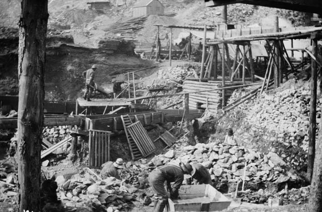
The benign neglect that the Canadian government exhibited towards its holdings in the North ended with the discovery of gold. Prospectors had been working the area for years, striking gold at such places as Fortymile in 1886, but the major discovery was made in the summer of 1896, by George Carmack, Skookum Jim, and Tagish Charley at the Klondike River. When news of the discovery reached the outside world in 1897, it seemed as though half of North America dropped what it was doing to head for northern Canada. Although a few miners took all-Canadian routes, such as the trail through Edmonton, most of those going to the Klondike took passage to the Alaskan town of Skagway, climbed over the Chilkoot or White pass into Canadian territory, and then travelled from Lake Lindeman or Lake Bennett down the Yukon River to Dawson City.
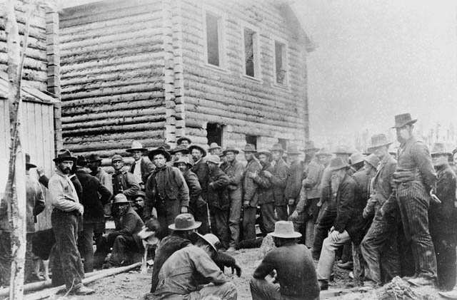
Of the many people who arrived in search of gold, most were Americans, who not only established towns with a reputation for lawlessness in their own territory -- such as at Skagway and Dyea -- but also spread into Canadian territory. Instead of appealing to conventional authority, miners administered justice through informal meetings at which all the members of a community gathered to hear disputes, and decide on punishments. Many miners felt that as they, and not the Canadian government, were the people developing the territory, they should not be bound by Canadian rules and regulations. Customs duties on gold from strikes often went unpaid. All of these factors presented challenges to Canadian control of the area.
"Sgt. Preston to the Rescue!"
Early Canadian actions toward establishment of sovereignty were made with the assistance of the North West Mounted Police (NWMP). As early as 1893, requests were made for the presence of an authority other than the miners' meetings. After official investigation into the matter, 20 men went to the region in 1895 to establish Fort Constantine. This contingent increased to 196 by 1898. At the gold rush's height, there were upwards of 300 NWMP officers in the territory. Their presence was augmented by two hundred soldiers from the Canadian army, called the Yukon Field Force.
The NWMP came to be a prominent symbol of Canadian authority in the Yukon, embodied by such men as Sgt. Sam Steele. In addition to their duties as keepers of the peace, they acted as agents of the government in all aspects of Yukon life. Establishing posts at the tops of the Chilkoot and White passes, on the Canadian border, Steele and his men acted as customs and immigration officers, turning away "undesirables", preventing guns and other illegal items from entering the territory, and ensuring that each potential prospector had enough supplies to last for six months. They also served as claims agents, safety officers, postal workers, and -- on occasion -- medical staff. Despite the large numbers of men who were used to the freedom of the frontier, most miners were content to maintain law and order and acceded to the NWMP's regulations.
Canadian Government
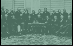
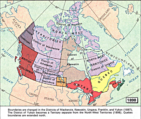
The Canadian government began establishing a more permanent authority in 1895, when it named the Yukon one of four new districts within the Northwest Territories -- along with Mackenzie, Franklin and Ungava. The government also recognized the Yukon's special status within the Territories, sending Inspector Charles Constantine of the NWMP as the government's primary agent in the district. Nevertheless, the region was still officially governed from Regina, the territorial capital.
 |
"An Act to provide for the Government of the Yukon District" (short title: The Yukon Territory Act), Statutes of Canada 1898 (v. I-II), c. 6, p. 55.
Copyright/Source |
Rapid population growth soon made the government realize that further action was required. As well, the people living in the Yukon were clamouring for more governmental representation -- at least at the local level. As a result, Canada passed the Yukon Act in 1898, designating the Yukon as a separate territory, with the capital at Dawson City. To administer the area, James M. Walsh was appointed Territorial Commissioner. (Walsh soon resigned, and was replaced by William Ogilvie.) The Commissioner governed with the aid of an appointed council of four members, all of them Canadian government officials. Because of the instability of the area and the strong American presence, the Canadian government did not immediately appoint local members; initially, the council's proceedings were even closed to members of the public.
After the Gold Rush
Unfortunately, the rosy future predicted for the Yukon in the wake of its becoming a partner in Confederation failed to materialize. As gold resources became depleted, the territory's population decreased, many of the miners moving on to other strikes, in places such as at Nome, Alaska. After 1904, the administrative presence in the territory was greatly reduced, and there was talk of replacing the elected council with appointed members. This action was avoided, although the number of members was reduced to three in 1919. The once roaring Dawson City saw its saloons and dance halls close one by one. The city eventually lost its status as territorial capital to Whitehorse in 1953. The Yukon's population only approached gold-rush-era levels with the construction of the Alaska Highway during the Second World War, an event that brought thousands of American servicemen into the area.
Sources
Black, Martha L. -- Martha Black. -- Edited and updated by Flo Whyard. -- Rev. ed. -- Anchorage, Alaska : Alaska Northwest Publishing Co., 1986. -- 166 p.
Berton, Pierre. -- Klondike : the last great gold rush, 1896-1899. -- Rev. ed. -- Toronto : McClelland & Stewart, 1972. -- 472 p.
Canadian encyclopedia : year 2000 edition. -- Ed. James H. Marsh. -- 3rd print ed. -- Toronto : McClelland & Stewart, 1999. -- 2573 p.
Coates, Ken S. ; Morrison, W. R. -- Land of the midnight sun : a history of the Yukon. -- Edmonton : Hurtig Publishers, 1988. -- 336 p.
Morrison, William R. -- True North : the Yukon and Northwest Territories. -- Toronto : Oxford University Press, 1998. -- 202 p.
Zaslow, Morris. -- "The Yukon : northern development in a Canadian-American context". -- Regionalism in the Canadian community, 1867-1967. -- Ed. Mason Wade. -- Toronto : University of Toronto Press, 1969. -- 300 p.
Top of page
|