 |
|||
|
|||
|
Copyright
Earthquake!
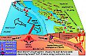
Last month Turkey, a neighbour just across the little Aegean Sea, was devastated by another of its many earthquakes. On December 7, 1988, the city of Leninakan, Armenia was shaken by an earthquake that measured 6.9 on the Richter scale and lasted more than a minute. The city of Spitak with 30,000 inhabitants, closest to the epicenter, was practically erased from the face of the earth. One margin of the Eurasian Plate, a major fault, runs along the coast of Yugoslavia, and through Greece. Through Turkey the Anatolian Fault lies along the Black Sea.
The Anatolian Fault has been responsible for many earthquakes. On July 10, 1949, a quake measuring 7.5 occurred in the Garm region of Tadzhikistan, in the south central former Soviet Union. This quake buried the village of Khait, killing 12,000. As a result, Soviet officals began a detailed study in Tadzhikistan. In this same area on August 31, 1968, a quake measuring 6.5 killed 12,000 in Iran and in '78 anaother measuring 7.7 killed 25,000 with a shock strong enough to rock buildings in Tehran, 400 miles from the epicenter in Tabas. In Turkey in 1975 one measuring about 6.8 produced damage throughout eastern Turkey and along the Black Sea. The Anatolian Fault has been responsible for more than 40,000 deaths since 1939 with 15 major earthquakes.
What happens"I saw buildings fly up in the air and become fragments..." The San Fernando earthquake of 1971 measured only 6.6 on the Richter scale but it moved the Upper San Fernando Dam five feet downstream and it settled by three feet vertically. Quick action to lower the water level prevented disastrous flooding of the San Fernando Valley. The quake at Charleston, South Carolina on August 31, 1886 was the most destructive on the Atlantic seaboard in historical times. It was felt over three million square miles from Canada to Mexico and from Bermuda to the Mississippi Valley. Great fissures ejected water and sand. Known as sand blows these ejections occur where the rise in pore-water pressure forces groundwater and sediment up through the surface in a muddy, sandy geyser. These geysers may spurt 12 feet high and leave yellow sand scattered in a radial pattern around a hole. Liquefaction is a hazard. This refers to the earth turning temporarily into a liquid state due to the rise in water pressure in unconsolidated sedimentary soil. This is what happened to a housing complex in the San Francisco earthquake (you know, the one we all saw on TV during the baseball game). Much of the area from Medford, Oregon through Portland to Seattle, Washington is underlain by river deposits that could liquify during a quake.
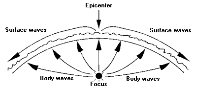
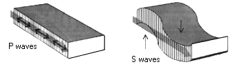
What are they?The focus of an earthquake can be anywhere from the surface to a depth of 450 miles or 280 km. The epicenter is the point on the earth's surface directly above the quake's focus. The primary or P wave is the first and fastest shock wave often accompanied by a low rumble. Also known as pressure waves, they travel deep into the earth and in some cases penetrate all the way through the earth to the other side. P waves contract and release material in line with their forward motion of travel through the earth – like boxcars on a railway track.
P and S waves are body waves that travel through the earth as opposed to surface waves. By correlating the information recorded at several seismographic stations that measure the arrival times of P and S waves, seismologists are able to determine the location of the focus.
Measuring earthquakesThe first "earthquake weathercock" was invented in China in 132 A.D. by an astronomer and mathematician named Chang Heng. It was a beautiful ornate cloisonn� model with eight dragons holding bronze balls in their mouths. An internal mechanism, triggered by a slight tremor, opened the mouth of one dragon, releasing the ball to sound an alarm as it clanked into the open mouth of a metal toad below. The direction of the quake was determined by the orientation of the dragon with the empty mouth.In 1935 Charles Richter (1900-1985) developed the principle of the Richter Scale for measuring the energy of an earthquake. A magnitude of 3.2 or more can be felt. Each number going up the scale, indicates 30 times more energy release. (e.g., 7.0 would release 30 times as much energy as 6.0 but 8.0 would release 900 times more energy than 6.0.) The Mercalli Intensity Scale, developed in 1931 by Giuseppe Mercalli, describes earthquake intensity in Roman Numerals from a low of I to a high of XII. XII would indicate complete and total destruction. This scale is based on eye-witness account. Duration is also important in measuring earthquakes because it is as responsible for damage as the strength of the shaking. To measure the bracket duration the seismologists determine the level of shaking that will mark the start and end of the bracket. For this, near the epicenter, they use accelerographs. The level usually chosen for the bracket duration is above .05 g. "g" (for gravity) is the acceleration of a falling body. A falling body increases its speed by 22 miles per hour or 35 kilometre per hour. This has also been noted as 32 ft./sec./sec.
Plotting the locationsAn Irish engineer in the mid-1800s made the first earthquake map of the world. Plotting the locations of all reliably recorded earthquakes in the world, he drew a strange looking map, showing that earthquakes are not distributed eavenly over the globe. They are concentrated in a handful of curved "belts" encircling the earth. The two circum-Pacific charts have become known as the "ring of fire" and contain three-quarters of all the earthquake and volcano activity on earth. California is a part of this ring and hundreds of earthquakes – most of them tiny but some perceptible to the unaided senses – shake the state on any given day. Earthquakes are ten times more common in California than over the globe as an average.The Pacific Northwest is part of this ring. A major seismic gap in this area is locked and remains quiet at the moment. Puget Sound is the source of constant quakes of 2-3.0 with a quake of 4.0 about every six months or so. An earthquake zone along the St. Lawrence River valley between Canada and the United States reaches well into Quebec and New England, shaking them with repeated quakes. Mont Tremblant ("Quaking Mountain") is said to have been named for the vibrations caused by waterfalls but it seems more likely that the mountain became known as "tremblant" following an earthquake.
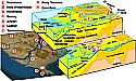
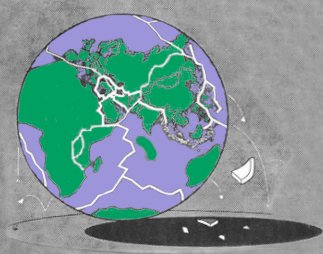
ResearchA geological plate is part of the Earth's surface that behaves as a single rigid unit. Plates are about 100 to 150 km thick and move in relation to the Earth's axis and to each other. There are seven large plates: the African, Eurasian, Indo-Australian, Pacific, North American, South American, and Antarctic; and several smaller ones. A Plate boundary is the line between two plates that touch each other. Plate boundaries are marked by seismic activity and tectonic activity. (Longman's Illustrated Dictionary of Geology, 1982) A geological fault is a break in the rocks along which movement has taken place.An indicator of the newness of the science of seismology is that so many of its pioneers studied earthquakes as a passionate hobby while engaged in more established full-time fields of inquiry. It was one such investigator, a Yugoslavian meteorologist name Mohorovicic who, by studying the speeds of P waves and S waves, came to the conclusion that there is a boundary between the outer crust and inner layer of dense rock at a depth of about 30 miles. At the boundary, seismic waves split into two groups -- one group continuing through to the earth's crust, the other group being refracted along the top of the denser rock below the boundary and attaining greater speed. This boundary was later named the Mohorovicic Discontinuity or the Moho for short.
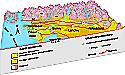
Virtually all earthquakes are caused by the slippage of masses of rock along fractures called faults. A fault zone is where the edges of two plates meet. The movement of tectonic plates slowly creeping builds up so much strain energy at the fault zones that they must slip. Rocks possess elastic properties which allow them to accumulate strain energy. There are two basic types of movement along a fault, one is known as a strike-slip in which the movement is horizontal along the edges of the plates. The other type is known as a dip-slip in which the movement is vertical. The St. Lawrence River valley is a rift, an area where a two crustal plates are pulling part and creating tension. Rifts are also very earthquake prone. The discovery of the mid-Atlantic ridge which bisects the Atlantic Ocean from the Arctic to the Antarctic was a major advance in the knowledge of tectonics and earthquakes. In the middle of this ridge, composed of basalt, is a rift eight to 30 miles wide and deeper than Arizona's Grand Canyon that runs the full length of the ridge. The total picture indicates that each great plate on the earth's crust is being thrust down into the mantle on one edge, known as a subduction zone, and melting back into the earth's magma, causing severe quakes. The Juan de Fuca plate subduction data suggests a possible earthquake on the magnitude of 8.0. In other areas (notably the mid-Atlantic rift), magma is welling up to build new earth crust that widens the oceans, moving the continents around in the process. Convection cells in the earth's mantle are thought to be responsible for plate movement. Recent technology – CAT scanning – has given us a detailed look into the mantle. Giant streams of magma seem to be rising and descending like plumes. The dynamics of the mantle are proving much more complicated than was ever suspected. In addition, a computer projection of crustal plates gives an indication that the earth is growing larger – that it is approximately one fifth larger than it was 180 million years ago! Extensive mathematical calculations show the travel times of P waves are affected by a dense core estimated to be 1800 miles below the surface and with a molten outer edge. Waves move faster through dense "cool" rock and slower through the thinner "hot" zones. As a result scientists now know the earth's core is composed of an inner core and an outer core, and a transition zone dividing a solid inner kernel from its surrounding sea of molten rock. It's mantle too, has an upper section and a lower one, and some concentric envelopes of elusive discontinuities. It is in the region of the upper mantle that the driving force behind earthquakes lurks. Tests on squeezing rocks in a compressor show rock tends to swell before fracturing, as a result of hairline cracks opening up. In addition, the rock becomes more porous and conducts electricity more easily, but slows down high frequency waves. So, when dilatancy opens cracks in the fracture zone, air is introduced and P waves slowed. At maximum cracking, before actual fracturing, ground water seeps into cracks restoring water pressure and P wave velocity is normal. The entire process could take years. As a result of these studies, several earthquakes were predicted successfully. The Institute of Geodynamics National Observatory of Athens (NOA) has been in continuous operations since 1893 when the first "Brassart" seismograph was installed in Athens. In 1879 the first national seismic network began it's operation. It began expanding operations in 1965 and in 1983 the first national telemetric network began operations. Complementary to the real time seismic data, NOA operates a 40-station analog strong-motion network and a 10-station digital strong-motion network. NOA also provides a real time seismicity catalogue of Greece as well as other relevant information and links through it's world wide web page at www.noa.gr.
A revolutionary ideaDeep gas is a new theory. Hydrocarbons (petroleum compounds, for instance) are believed to come from long-buried vegetable matter converted by heat and pressure. Dr. Thomas Gold of Cornell University believes the hydrocarbons were deep inside the earth from the beginning, seeping back to the surface after "cooking" inside the globe. This releasing of hydrocarbon gas is building up great pressures, setting off earthquakes at fault zones. The deep gas theory would also be an explanation for earthquake light, a pale glow that has been frequently seen in the night sky during an earthquake.
Some of the greatestThe earliest recorded quake was in Shensi, China in 1556, reportedly killing 830,000 people. Another noteworthy quake in China was in Kansu Province in 1920. This triggered the worst landslide in recorded history and killed 180,000. After the disaster, it took a survivor one week to walk to the nearest telephone to let the world know! On July 28, 1976, in Tangshan, China a quake measuring 8.3 on the Richter Scale killed 3/4 million people and did what is reputed to be the most damage. It was one of a series of earthquakes in an arc from Italy through Uzbekistan in the former U.S.S.R. to the New Hebrides off northern Australia, caused by a northward surge of the African and Indo-Australian plates and responsible for the greatest death toll in 400 years.The largest earthquakes known measured an estimated 8.9 on the Richter Scale. There were three – Lisbon, Portugal 200 years ago, killed 60,000 and affected 6 million square miles; Colombia and Ecuador January 31, 1906 and Honshu, Japan March 2, 1933. The most powerful earthquake in North America was at Anchorage, Alaska on Good Friday, March 27, 1964. Whole blocks of houses slid about, pavements burst open, fissures up to 30 feet wide opened and closed. The land had turned to liquid, with billowing undulations measuring as much as three feet from crest to trough. The quake in the Aleutian Islands, Alaska on February 24, 1965 had 750 measurable after shocks. An earthquake in Peru in 1970 caused an avalanche that buried a town under 33 feet or 10 metres of rubble, killing 18,000 people. The disastrous Mexico City quake on September 19, 1985 measured 7.8 and was the result of the slippage of the Cocos and North American plates. In 1811 a quake in the Mississippi Valley at New Madrid, Missouri measured 7.2, affected two million square miles and created a lake 37 miles (60 kilometres) long. The famous San Francisco quake on April 18, 1906 is estimated to have been 8.25 and killed 453 people. In August 1959, the aftershock of an earthquake in Montana caused Yellowstone Park's 8257-foot Mount Jackson to shrug off thousands of tons of rock. Earlier, the main shock affected 500,000 square miles, creating a new lake and reactivating 160 dormant geysers. This earthquake was the strongest ever recorded in the Rockies. The entire area of Yellowstone Park is the sunken crater of a gigantic prehistoric volcano. Scientists discovered an enormous pear-shaped body of magma, some 30 miles in diameter and up to 150 miles deep, lying just under the park. The region gives off heat at 20 times the normal rate for the rest of the continent – truly a hot spot.
PredictionsAt present scientists cannot predict with any certainty when an earthquake will strike. In California a severe quake measuring 8.0 or more has occurred once every 100 to 150 years. The lastt tremendous quake was at Fort Tejon in 1857. Because the Pacific plate is moving northwest at the rate of approximately two inches or five centimeters a year, there is a good chance that an earthquake of the magnitude of 8.0 will happen along the 700 mile San Andreas Fault some time before the year 2007.Some reported precursors of earthquakes have included change in the tilt of the land or a change in elevation, or bulging. In Russia they have noted a slowing of pressure waves. California has not shown this. China and Italy have reported a rise in the level of the water table, the presence of radon gas in the water supply, and a weakening in the magnetic field at the epicenter as precursors. It has also been reported that animals who live in holes in the ground such as snakes, ground hogs, and rats will come out to the surface before a quake. Birds become very disturbed. These animals with more finely tuned senses may be aware of extreme stresses in the earth some time before the quake strikes. The Russians found evidence of early-warning signals. For a period of time before a tremor, records showed fluctuations in relative speeds of P and S waves. Normally P waves traveled about 1.75 times faster than S waves. The ratio would drop to 1.6 for days, months or years, then return to normal. Shortly after, there would be a relatively large tremor. The longer the ratio stayed below normal, the greater the tremor. This information was presented at a science meeting in Moscow in 1971. This line of research was pursued in the Adirondacks, New York where changes in seismic wave properties were suspected. P waves were more affected than S waves. Geophysical research at CalTech, California, found the same results prior to the San Fernando earthquake, discovering the P waves changed speed by slowing down 10-15%. Geologists have had some small success in predicting small earthquakes such as those in northern New York to Quebec, but the really big ones defy any accurate predictions. Time, place and magnitude are what are required for an accurate prediction, but time is most difficult. There really is still no reliable way to predict an earthquake. The geologists need much more history over the ages to help them build a picture on which to make predictions. In 1974-75, the Chinese, watching the warning signs of earthquakes, discovered ponds and canals became roiled and muddy and gave off unusual odors. The sky glowed with eerie neon-like flashes and balls of fire, perhaps due to methane gas. They predicted an earthquake near the port of Ying Kow within six months. Then wells started bubbling, rats and mice left their holes weaving drunkenly and snakes came out of hibernation. A swarm of tremors began (500 in a period of 72 hours) and a 4.8 jolt came in the morning. Then all was quiet. Several hours later, citizens were notified to leave their homes. Three million people, without panic, closed shops, extinguished fires and moved into open spaces. Patients were evacuated from hospitals and farm animals were taken out of barns. At 7:36 in the evening the quake struck. Lightning flashed and 15-foot jets of water and sand shot up in the air. 40% of the buildings were destroyed, but in an area of three million people, only about 300 were killed. In January 1976, the Chinese earthquake watch noted changes in gravity and electrical resistance together with a sharp change in magnetism. An open-ended alert was issued. Late in July there were sudden changes in groundwater level and strange animal behaviour. At 4:00 a.m. on July 28, 1976, the population was awakened by incredible sheets of white and red lights blazing in the sky and visible for 200 miles. Suddenly the ground shook and 20 square miles fell into utter ruin – all that stood upright was a single smoke stack. At Tangshan the epicenter registered 8.3 and in some places the lateral movement measured four feet. Sixteen hours later there was an aftershock of 7.4 and over a period of 48 hours 125 tremors measured at least 4.0. There is not much that mere mortal man can do except try to build quake-proof structures away from a fault on solid ground. Never build your house upon the sand or on sedimentary soil. It isn't usually the quake that kills, but the buildings and objects that fall on people. California and Japan have made the most extensive plans to prepare for earthquakes, studying high risk areas and correcting weaknesses as they see them. They have developed earthquake response plans, drawn up guidelines and preparedness plans for the populace.
PrecautionsA few common-sense precautions will reduce some of the hazards of a quake if you live in such an area:
These are simply good precautions to guide anyone – wise disaster preparedness advice. Less than one minute hardly gives anyone time to recognize what is happening, let alone time to take any defensive action. One must be prepared beforehand.
References:
Reading List:Books:
Periodicals:
Other Publications:
This article may not be copied, distributed or reprinted in any form without the author's permission. To contact the author, please use the e-mail address provided. If you are unable to contact the author, please contact the Canadian Rockhound. Authorized reprints must acknowledge the author, original source and the Canadian Rockhound, and include the website URL address of the Canadian Rockhound. The preceding article is a modified and updated version of an article first published in the Jan/Feb 1989 (Vol. 1, No. 6) issue of Cab & Crystal, a Silver Chameleon publication. Images from UBC EOS website © Geological Survey of Canada.
|
||||

Copyright © 2000 Canadian Rockhound
Magazine Issues |
News & Events |
Junior Rockhound |
Resources
|
||||