 | |||||
| About Us | Contact Us | Services | Copyright | |||||
|
|||||
|
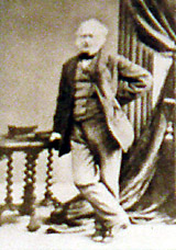
Sir William Logan, 1795-1875 Founder of the Geological Survey of Canada and innovative cartographer By Marilyn Fraser
In 1818 he joined his uncle Hart's bank in London, England, becoming manager on his uncle's retirement. In 1831 he joined the management of a copper-smelting and coal-mining venture near Swansea, Wales in which his uncle had an interest. Logan stayed until his uncle's death in 1838. It was here that Logan's keen interest in geology was triggered. While learning the business, he began to study the geology of the area. A systematic thinker, looking for reliable sources for coal, Logan produced geological maps of South Wales, together with cross-sections which were exhibited in Liverpool, England in 1837. Introducing cross-sections, representing hypothetical vertical slices of the Earth's crust to depict the land surface and succession of strata beneath it, was an important innovation in geological cartography. This practice was adopted by the Geological Survey of Great Britain (G.S.G.B.) in 1844. Under Sir Henry de la Beche, its first director, the G.S.G.B. recognized the excellence of Logan's work and incorporated it into the Survey's report on the region. De la Beche told Logan he considered him to be the best geological mapper in Britain.
From then on, William Logan devoted all his time to geology, especially the geology of coal formations. In 1840 he had presented a report to the Geological Society of London on his theory of the in situ formation of coal, enabling geologists to determine the location of deposits of carboniferous strata. During this time, the Industrial Revolution was fuelled by the mining of coal and iron ore for steel-making. The Province of Canada was an undeveloped fringe of farming settlements along the edge of a vast, unknown hinterland of forest and rock. With a population of about two million people, served by only eight kilometers of railway track, it had a mining industry that produced a little iron for horseshoes, door nails, flat irons and other local uses. Other economic minerals were not even. At the urging of the small mining sector, the government of Canada under Sir Charles Bagot set out to take an inventory of its mineral wealth. In September 1841, the Legislature of the Province of Canada passed the resolution "that a sum not exceeding one thousand, five hundred pounds sterling be granted to Her Majesty to defray the probable expense in causing a Geological Survey of the Province to be made."
News of the resolution came to Logan as he was commencing a tour of the coalfields of Pennsylvania and Nova Scotia. His interest was aroused and he let it be known that he would consider the position of director. Logan's knowledge of geology and his reputation had increased steadily since 1837 and his bid for the position was bolstered by recommendations from prominent scientists in England. His appointment was made the following year and by August 1842 Logan had arrived in Kingston, the seat of the Provincial Legislature.
The rapid industrial advances in England since the late 18th century had show how essential coal was to economic expansion. With the accepted belief that North America's destiny lay in applying industrial technology to rich natural resources, the search for coal became the Survey's first priority. It was set an impossible task: to survey and map the geology between the Gaspé Peninsula and Lake Superior.
In the spring of 1843 Logan returned to Canada and established the headquarters of the Survey in "a small dark room" in part of a warehouse on Montr�al's St. Gabriel Street. The work now began in earnest. The Geological survey of Canada's first field season saw Logan working between Pictou, Nova Scotia and Gaspé, and Murray between Lake Erie and Lake Huron in Ontario. This established a tradition of research in the field that continues to this day. The following year, Logan and Murray, with a larger group mapped the north shore of the Gaspé Peninsula and their travels brought them to the mountains along the Cap Chat River, the highest of which was named in Logan's honour by his assistants (this Mount Logan is not to be confused with Canada's highest mountain, which is located in the Yukon and ALSO is named for him). Logan was a brilliant choice for director, a diligent, careful worker instilled with a zest for knowledge and a good geologist's tireless propensity for wearing out walking boots.
Like most good leaders, he was not malleable in the hands of his superiors. He had undertaken a two-year commission to carry out a geological survey but he knew this was only a beginning and from the first he had a definite strategy: prove the value of the survey to the government and so ensure its eventual continuity. To do this he emphasized the practical aspects of the work.
Based on information gathered during the first two field seasons, Logan reported that no coal deposits were to be found in either Upper or Lower Canada. Even though the entire province of Canada had not been searched, it was clear to him that all the rocks it contained were older than the earliest known coal-bearing formations. Consequently, there was no possibility of such deposits being found. This was disappointing news inasmuch as coal was then the energy source essential to the development of an industrial economy but the report undoubtedly prevented spending thousands of dollars fruitlessly. Logan, however, did make many important discoveries in the early days of the Survey. He established several broad geological divisions – folded Paleozoic rocks covering Gasp� and the Eastern Townships, the all but flat-lying limestone Paleozoic rocks extending west from Montr�al to Lake Huron, and a third division of much older crystalline rocks that extended north from Kingston, Ottawa and Montr�al. The latter proved to be the southernmost exposure of the great Canadian Shield – a mineral treasure chest of unflagging interest to prospectors and resource geologists to this day.
By the end of 1844 the £1,500 allocated by the government for survey work had been spent, along with some of Logan's own money. The results of the first two years had clearly demonstrated the benefits of a systematic geological survey. As a result, in 1845, the mandate of the Geological Survey of Canada was renewed with funding of £2,000 a year guaranteed for five years. Logan then made a pivotal decision to remain as director rather than accept an attractive and challenging appointment to India. Logan then went on with the work, making a traverse along the Ottawa River to the head of Lake Temiskaming and westward to Lake Nipissing, to study the very old and complex rocks of the Canadian Shield whose history has been all but obliterated by intense geological changes to which these rocks have been subjected. In the early days, the fluently bilingual Logan concentrated on determining Canada's coal resources. He quickly expanded his summer field searches to include a wide range of minerals.
"Only those familiar with this type of work will realize its arduous nature – the long hours of paddling and scrambling over rocks or through dense bush along the shore, portaging around falls and rapids, enduring swarms of pestering insects, and collecting specimens," wrote Morris Zaslow in Reading the Rocks, an official history of the G.S.C. Another hazard was public ignorance of geology. Logan, who routinely put in a 12-hour day in the field, pocketed rocks and counted off paces as he walked. In Sir William Logan and the Geological Survey of Canada, Dr. Robert Bell describes how Logan was often taken for a lunatic because of his peculiar appearance and odd behaviour. Once, when performing field work in the Gaspé Peninsula, "It was remarked 'he carries a hammer and pounds the rocks, like an idiot.'" The local authorities decided he should be sent to the Beauport Lunatic Asylum. "His long zigzag walks on the beach convinced them that he was not only hopelessly demented, but was rapidly getting worse, so while he was in the act of making one of his slants across the measures, he was seized by two men," Bell writes. Fortunately, Logan quickly explained his strange behaviour and was allowed to carry on with his work. Logan wrote of himself, "I fancy I cut the nearest resemblance to a scare-crow. What with hair matted with spruce gum, a beard three months old... a pair of cracked spectacles... [and] a waistcoat with patches on the left pocket where some sulphuric acid, which I carry in a small vial to try for the presence of lime in the rocks, had leaked through." "I worked like a slave all summer on the Gulf of St. Lawrence, living the life of a savage, inhabiting an open tent, sleeping on the beach in a blanket sack with my feet to the fire, seldom taking my clothes off, eating salt pork and ship's biscuit, occasionally tormented by mosquitoes," he wrote. "I dialled the whole of the coast surveyed, and counted my paces from morning to night for three months. My field book is a curiosity." Throughout his extensive travels, Logan did many water colours and drawings of the landscapes of Canada and Europe for his own personal enjoyment. While working, he often supplemented his geological observations with thumbnail sketches of the site being studied. Drawings from his field journals tell us much about field work in those days. He was a bachelor who worked day and night at his vocation, often sleeping in his office near his precious rock samples. Thousands of pounds of his own resources were poured into the ill-supported organization.
The infant survey was soon faced with a delicate problem – the nature of the relationship between a government agency and private enterprise. A copper mining boom in Michigan spread to the north shore of Lake Superior. Logan accompanied by Alexander Murray and James Richardson (a farmer and school teacher, the Survey's first photographer) carried out studies of mineral occurrences between Bruce Mines and the Soo. Logan had difficulty in making the point that the Survey's role was not that of a private consultant. One political crisis after another threatened renewals of the Survey's mandate, time and again. Eventually, Logan was obliged to drum up support form all sides – the Governor General, scientists at the University of Toronto, the Anglican bishop and John A. MacDonald. A new bill was passed but again for five years only, leaving the future of the organization at the whim of the legislature. However an additional £2,000 was granted for publication of a geological map and a condensed report on the geology of Canada. Conversion from sterling to dollars took place in 1859. The act again expired and due to the American Civil War it was not renewed. Logan had to go each year to the government and so was more exposed to the threat of an empty treasury than ever. Confederation in 1867 greatly extended the Survey's area of responsibility and in 1868 a new 5-year act retroactive to July 1, 1867, was passed. By 1869 Logan recognized a younger man was needed to carry the burden of a vigorous and growing organization and retired. By this time his honours were legion. Sir William Logan had been knighted 13 years earlier by Queen Victoria. He had received the Wollaston Palladium Medal, the highest honour of the Geological Society of London, and the Cross of the Legion of Honour from France. Because of his regard for Sir John William Dawson, he donated $19,000 to found the Logan chair in geology and funds for Logan medals. Both McGill University in Montreal and the University of Bishop's College in Lennoxville, Quebec, conferred honorary degrees on him. The excellence of his display of Canadian rocks and minerals at the London exhibition of 1851 led to his election as fellow of the Royal Society, sponsored by Sir Roderick Murchison – the first native Canadian inducted into the Royal Society of London for achievements in Canada. A similar exhibit at Paris in 1855 earned him the Grand Gold Medal of Honour from the Imperial Commission and investiture as chevalier of the Legion of Honor in the same year. A colourful, well-liked man with a knack for hiring dedicated and competent people and for inspiring them with enthusiasm for geological work, Sir William Edmond Logan went to direct the Geological Survey of Canada for another quarter-century. In so doing, he guided the organization through its formative years and laid the foundation for the future. Logan achieved so much that his record seems almost beyond belief. He was the first to probe, study and name the Canadian Shield. He founded a geological museum that grew and expanded to become a major part of the National Museum of Canada. Logan's book, Geology of Canada – 1863, is the bedrock of Canadian geological study. He also produced an atlas and our first geological map.
This article may not be copied, distributed or reprinted in any form without the author's permission. To contact the author, please use the e-mail address provided. If you are unable to contact the author, please contact the Canadian Rockhound. Authorized reprints must acknowledge the author, original source and the Canadian Rockhound, and include the website URL address of the Canadian Rockhound.
|
||||||||

Copyright © 2000 Canadian Rockhound
Magazine Issues |
News & Events |
Junior Rockhound |
Resources
|
|||||||||
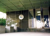 Entrance to the Geological Survey of Canada building in Ottawa.