 |
|||
|
|||
|
Copyright Proposed National Park to protect Manitoba's lowlands
CANADIAN NATURE FEDERATION A proposed Manitoba Lowlands National Park would protect a wide and impressive variety of fragile habitats, interesting geology, limestone carst caves, and picturesque shorelines.
History of the ProposalAfter several decades of studies in the region, the provincial and federal governments reached an agreement to initiate a feasibility study for this national park in 1992, setting out terms of reference for the study in 1994. Between 1994 and 1996 four distinct study areas were considered, and consultations regarding these were conducted. In March 1996 the federal and provincial governments released their proposed boundaries for a national park proposal within the study areas. Since then, community consultations have continued, with some extensions and changes to the 1996 boundaries released in November 1998.Negotiations for this park are complex, involving affected First Nations and local communities for each of up to four different components, as well as the federal and provincial governments. Currently the Manitoba government has committed to refraining from any resource extraction within the combined 1996 and 1998 proposed boundaries, although no formal legal protection is in place.
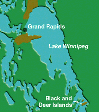
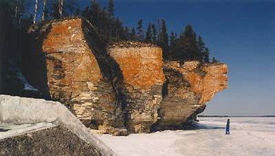
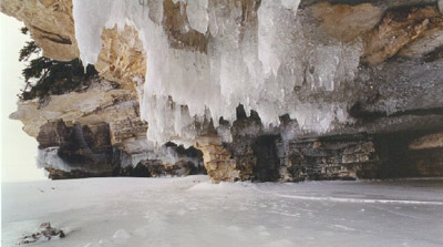
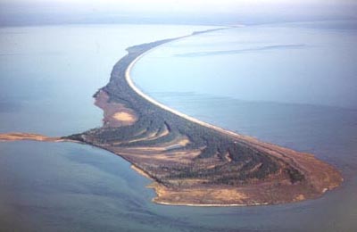
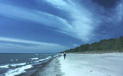
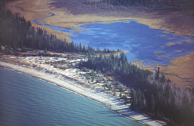
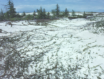
Unique FeaturesSituated between Lake Winnipeg and Lake Winnipegosis in central Manitoba, the park proposal is made up of three separate parcels of land: the Limestone Bay area, Long Point, plus Black and Deer Islands. Together these landscapes contain a wide and impressive variety of wildlife habitats in extensive wetlands, boreal forest, and trembling aspen-balsam poplar parklands. Countless ponds, lakes, and marshes - remnants of glacial Lake Agassiz - provide prime nesting grounds for a concentrated and diverse collection of inland colonial bird species. Limestone caves abound in the region, sheltering Little Brown and Keen's bats. Great blue herons, pelicans, cormorants, and piping plovers take advantage of the shorelines and long sandy spits. And wolves, black bears, elk, moose, and woodland caribou roam the forests. The park study area provides insights into the regions geological history with its glacial moraines and sandy beaches, as well as clues to part of the region's human history as an important route for fur traders and voyageurs.
ThreatsThe Manitoba Lowlands region is among the most altered and threatened landscapes in the country. The proposed national park lands are under intense pressure from development. Interim protection through the province of Manitoba is an outstanding and urgent need.
Stumbling BlocksNegotiations are complex because of the diversity of partners and interests. The current focus is to build grass roots support so that negotiations can proceed. Both the federal and provincial governments need to provide the resources and will to work together if progress is to be made.
Related WebsitesMore information about protecting Manitoba's lowlands (and other threatened areas in Canada) can be obtained online by visiting the following websites:
Copyright © 2001 Canadian Nature Federation This article may not be copied, distributed or reprinted in any form without the author's permission. To contact the author, please use the e-mail address provided. If you are unable to contact the author, please contact the Canadian Rockhound. Authorized reprints must acknowledge the Canadian Nature Federation and the Canadian Rockhound, and include the website URL address of the Canadian Nature Federation and the Canadian Rockhound. All photographs are copyright © 2000 by Roger Turenne of the Canadian Parks and Wilderness Society. Used with permission. Photographs used in this article may not be copied, distributed or reprinted in any form without permission. To contact the photographer, please send e-mail to Roger Turenne at rogerturenne@home.com. The preceding article is also available on the Internet through the Canadian Nature Federation's website at www.cnf.ca. All photographs were provided courtesy of Roger Turenne. Article reprinted in the Canadian Rockhound with permission from the Canadian Nature Federation.
|
||||

Copyright © 2001 Canadian Rockhound
Back Issues |
News & Events |
Junior Rockhound
|
||||