 |
|||
|
|||
|
Copyright
An Overview of the BY DAVID J. SCOTT * * Canada-Nunavut Geoscience Office, PO Box 2319, Iqaluit, NU, X0A 0H0
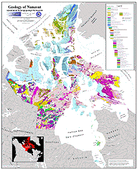
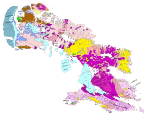
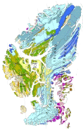
For the purposes of this summary, Nunavut's geological history can be subdivided into three main temporal blocks; the Archean (>2500 million years ago), the Proterozoic (2500 to 540 million years ago) and the Phanerozoic (<540 million years ago). Each era is characterized by a distinctive suite of rocks, tectonic events and resource endowment.
ArcheanRocks of Archean age are exposed throughout Nunavut, and undoubtedly underlie much of the territory that is covered by younger rocks. The Archean of Nunavut is characterized by "granite-greenstone" terranes, similar in most repsects to Archean cratons globally. Nebulitic migmatitic gneisses, that range from granodiorite to quartz monzonite, are among the oldest rocks in Nunavut and exposed in parts of northern Baffin Island, the Melville Peninsula, and southwest across the mainland. These rocks are complex and texturally diverse, ranging from massive to finely foliated and thinly banded. Schlieren, lenses and boudined bands of amphibolite, metasedimentary, granitoid and rare ultramafic rocks are present. Discordant mafic sheets that truncate early compositional layering in the rocks, but that are folded and locally boudined, may represent dykes that predate younger volcanic and sedimentary rocks.
Late plutonic activity is in large part synchronous with, to slightly younger than, volcanism in these greenstone belts, suggesting that there may be, in part, a genetic relationship between the extrusive rocks and some of the intrusions. Monzogranite to granodiorite plutonic rocks intrude both the greenstones and the older orthogneisses. A phase of high-grade metamorphism is locally recorded approximately 2500 million years ago across much of the Churchill Province.
ProterozoicMuch of the Churchill Province was covered by extensive siliciclastic sedimentary rocks in the earliest Proterozoic; this is recorded in the strata of the Hurwitz Group and related successions. Younger siliciclastic and carbonate rocks of the Penrhyn Group on the southern Melville Peninsula, and their along-strike correlatives of the Piling Group (central Baffin Island) represent the margin of an ancient Archean continent. The stratigraphically lowest rocks consist of quartzite and feldspathic quartzite, and are overlain by dolostone, marble and calcsilicate gneiss, with minor amounts of siliciclastic rocks and as well as rare rusty schist and minor sulphide-facies iron formation. Much of the upper part of the basin comprises a relatively homogeneous succession of grey-weathering psammitic rocks (turbidites) that are volumetrically the most important component of the Piling and Penrhyn groups. These rocks have elevated potential for base metal and gold mineralization; the Black Angel Mine, a past-producer of zinc and lead, is hosted in correlative carbonate rocks of the Karrat Group on the coast of central West Greenland.On southern Baffin Island, similar contemporaneous stratigraphy (the Lake Harbour Group) contains ultramafic sills that have recently been investigated for their nickel potential. In southernmost Nunavut, basal clastic rocks and overlying volcanic and carbonate units are well exposed on the Belcher Islands in southern Hudson Bay. These rocks record the subsidence and rifting of the western margin of the Superior craton. Paleoproterozoic deformation, and a strong, attendant thermal overprint, are recognized throughout the map area. These Proterozoic successions were deformed and metamorphosed during the ~1800 million year old Trans-Hudson Orogen, a period of global collisional and accretionary mountain building.
Diabase dykes, tens to hundreds of metres wide, and tens of kilometres in length, comprise the NW-trending Franklin swarm. These unmetamorphosed tholeiitic dykes were intruded approximately 720 million years ago.
PhanerozoicPaleozoic rocks cover approximately one-third of Nunavut. Strata lying to the west and northwest of Fury and Hecla Strait are part of the Arctic Platform that continues northward onto Ellesmere Island, whereas those to the southeast underlie the Foxe Basin and represent the northern continuation of the Hudson Platform.The strata from earliest Cambrian time, characterized by a thick clastic sequence, record the initial subsidence and rifting of the continent, and subsequent marine inundations. From the Cambrian to the Silurian, thick carbonate successions record stable platform conditions; these rocks have significant potential for oil and gas reserves. From Late Silurian until Early Devonian time, much of the Arctic Platform was affected by the Caledonian mountain-building event; uplift and erosion led to the deposition of a thick orogenic clastic wedge, with elevated potential for red-bed type copper deposits. In the late Devonian, east-west compression (Ellesmerian mountain-building event) may have been the driving force behind the Mississippi-Valley type mineralization that gave rise to the zinc-lead deposits of the Polaris district in the central Arctic archipelago.
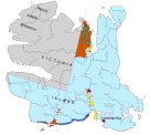
From Carboniferous to Cretaceous time, renewed rifting led to the formation of the Sverdrup Basin in northernmost Nunavut, characterized by the deposition of a thick clastic and carbonate succession. These strata host significant reserves of gas and oil, including the past-producing Bent Horn light crude oil field. In the late Cretaceous until early Tertiary time, renewed rifting led to alkaline volcanism and the deposition of a succession of silicilstic rocks in northern Baffin Island, southwestern Bylot Island, as well as northern Ellesmere Island. These rocks are remnants of a succession that covered much of the Canadian Arctic archipelago, deposited as a consequence of local uplift driven by a complex series of tectonic plate adjustments related to the opening of Baffin Bay and the Labrador Sea. In northernmost Nunavut, the Eureakan mountain-building event is characterized by compression and strike slip faulting, a consequence of the rotation of Greenland. In eastern Nunavut, a cluster of kimberlite pipes is centered on Somerset Island, with exposures on the northern Brodeur Peninsula and northwestern Baffin Island. Several of these pipes are known to be diamondiferous; they were emplaced approximately 100 million years ago. In western Nunavut, diamondiferous pipes such as Jericho occur in the northern continuation of the Lac des Gras field in the northern Slave Province. Numerous other pipes have been identified on Victoria Island.
Copyright © 2001 David J. Scott This article may not be copied, distributed or reprinted in any form without the author's permission. To contact the author, please use the e-mail address provided. If you are unable to contact the author, please contact the Canadian Rockhound. Authorized reprints must acknowledge the author and the Canadian Rockhound, and include the website URL address of the Canadian Rockhound.
|
|||||||

Copyright © 2001 Canadian Rockhound
Back Issues |
News & Events |
Junior Rockhound
|
|||||||