|
Back to Forestry Forest Management History of Logging |
Blind River District Fire #9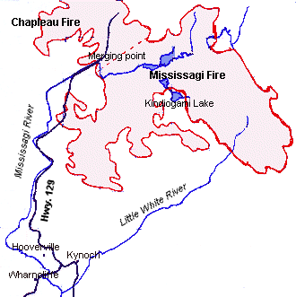 The fall of 1947 and spring of 1948 had been very dry, perfect conditions for what became one of the worst forest fires in Ontario. On May 25th, an aerial forest mapper spotted a fire near the headwaters of the Sharpsand River, in the Mississagi Provincial forest. His report confirmed a sighting of smoke reported by the Ranger Lake fire tower. On that day it was estimated that the fire had consumed between 15 to 25 acres. Twenty-eight men were brought in to fight the fire on the 26th, as well as 40 men from the Hydro (Rayner) dam project near Wharncliffe. Seven thousand acres were engulfed in flames by May 27th, with 137 men attempting to put out the blaze. The fire had jumped the Mississagi River in three places. By the next day the fire had spread to 29,000 acres with a 45-mile fire front. Between May 29th and 31st the fire spread to 65,000 acres. Four hundred and fifty men battled the fire round the clock. June 1st saw the fire moving east towards Kindiogami Lake, threatening lumber camps there. With bulldozers and backfires and the technique of damping down the camps, fire crews were able to save the camps. Quite often men were forced to seek refuge in lakes. Meanwhile, a blaze south of Chapleau was burning out of control. The two fires burned towards each other until they were separated by only a few hundred acres. The fire had consumed 170,000 acres. One hundred and fifteen men were flown in, as well as 700 men from the power dam. On June 9th 300 men were diverted from the Mississagi fire in an attempt to hold the Chapleau fire back. Despite their efforts, the two fires met on June 12th. At this time attempts were made to seed the clouds with dry ice. The resulting showers were insufficient to have any effect on the blaze. The fires continued to burn out of control, until June 23rd when it finally rained. With the help of the rain, the fire fighters were eventually able to get the fire under control. One month later, the fire was officially declared under control. By July 31st crews were able to start pulling out, though some remained to keep an eye on the hot spots. The fire was officially declared out on August 31st. Amazingly, no lives were lost. Even the fire-fighting team, 3,500 strong, all survived. The fire burned 1,000 square miles in all. The Mississagi fire alone burned an area of 446 square miles. Smoke from the fire blew as far as 2000 miles south into the United States, going so far that the streetlights in several Texas towns would turn on during the day. Closer to home, it was remembered that the smoke was very bad for a couple of days. It was hard on the eyes, one man remembers, and in the afternoon on one Sunday it got so dark that the chickens, thinking it was night, went to roost.
|
 It was believed that the fires were caused by crews building highway 129 north of Peshu Lake, and by a poacher's fire south of the lake. It was estimated that around 206 million board feet of white, jack, and red pine, as well as 316,481 cords of maple, birch and poplar, were lost in the fire. In the fall of 1948, the Ontario government launched Operation Scorch, in an effort to salvage the 300 million F.B.M. of timber that remained in the burned area. Much of the timber salvaged from the area was used in the post-war building boom. Today all evidence that a fire took place is covered by the new growth. But walking through the bush, you can see the great charred stumps of the mighty pines that once grew there.
Home | Natural Environment | History | Industry | Personalities/Stories | Credits/Team