


Peace River Lowlands Climate
 The climate of the Peace River Lowlands Subregion is characterized by
cool summers and long, cold winters. The mean annual temperature is minus 3.5 degrees Celsius while the average May to September temperature is about 11 degrees Celsius with a range between 10-13 degrees Celsius, increasing slightly to the northeast. Total annual
precipitation is divided equally between snow and rain and the total precipitation averages about 250 millimetres between the months of May to September, increasing to the southeast.
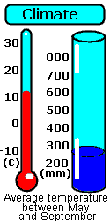
The climate of the Peace River Lowlands Subregion is characterized by
cool summers and long, cold winters. The mean annual temperature is minus 3.5 degrees Celsius while the average May to September temperature is about 11 degrees Celsius with a range between 10-13 degrees Celsius, increasing slightly to the northeast. Total annual
precipitation is divided equally between snow and rain and the total precipitation averages about 250 millimetres between the months of May to September, increasing to the southeast.