| |
|
|
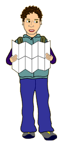
When we want to find our way in unfamiliar territory, we "orient" ourselves. This means that we match what we know about the region on the map with what we see around us. With a map, we look at the land features it portrays, and then look around us to understand where they are located in real life. For instance, when you give directions to a friend's house you might say "Turn left on Hunter Street near the music store, and then stop across from the camera store." Maybe you are the "navigator" on a road trip to a friend's cottage. You are reading a road map and your friend has given you several land features to orienteer your way to the cottage. You know that you have to turn off at Exit 9, drive 16 kilometres until you see the General Store, turn right at the T-junction and then drive 34 kilometres until you see the old train bridge. You then must turn left and follow the dirt road for 15 kilometres until you see a special cluster of rocks. Turn into the driveway there and, voila you've arrived! Orienteering using a compass is very similar, only instead of following roads, you would take azimuthal bearings from point to point.
Hands-On Activity
Hold any kind of map from your region or area out in front of you. It could be of a local park, your schoolyard or classroom, or a bus route or road map. Now, orient yourself so that what you see on the map, you can see in real life when you look up from the paper.
|