Numerous archaeological sites in the Chilliwack River Valley attest to First Nation's connections to the Valley. Evidence from other locations, principally the Fraser Canyon and Hatzic Rock site, suggest that people may have lived in the valley for about 10,000 years. Housepit depressions, village sites, a fish trap weir and lithic scatters are identified in the valley. First Nation's people not only used the Valley floor but gathered food and hunted on the adjacent mountains and hillsides as well.
In 1858 when gold was found in the Fraser Canyon area near Yale, gold seekers travelled east up the Chilliwack River Valley. At the same time, a contingent of Royal Engineers arrived in the colony to begin the task of surveying the border between the Crown Colony of British Columbia and the United States. The border was established with the signing of the Oregon Treaty on 1846 but the exact location needed confirmation. The Royal Engineers travelled the same trail, as they surveyed the boundary.
In 1859, Lieutenant Charles Wilson, a Royal Engineer, wrote, "The Chilukweyuk stream is a tributary of the Fraser & rises in the far recesses of the Cascade mountains & by its valley we penetrate the mountain range later on in the season. The Indians give a wonderful account of a lake near the summit, where bears, marten, marmot & salmon abound; a reconnoitring party sent forward give glowing accounts of the fishing." (Stanley, George F. Mapping the Frontier, Charles Wilson's Dairy of the 49th parallel, 1858-1862. P. 49).
This initial influx of people seems to have been followed by a period of relative inactivity, although prospectors continued to visit the Valley. In 1909, gold was found on Red Mountain, in the United States. Access to the mountain was through the Chilliwack Valley and a number of local packers were employed by the owners of the mine.
In 1924, railroad logging came to the Chilliwack River Valley. The Campbell River Timber Company operated the line until 1928 when they ceased production. B. & K. [Brown & Kirkland] Logging and later Vedder Logging continued logging in the Valley through the 1930s. Camps were established at several locations including Bowdenville. Vedder Logging left the area in 1943. After that many smaller companies continued the logging tradition.
Since the Second World War the economy of the Valley has diversified. A Forest Service nursery, fish hatchery, prison camps and small farm operations have added to the mix in the Valley. Several housing developments are located along the Chilliwack River Road. In recent years the river has been used for rafting and as a training centre for kayakers. Fishing for salmon and steelhead remains a tremendously popular for area and visiting fisherman.
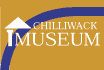
Logging train of the Vedder Logging Company, with the Chilliwack River on right, ca. 1935. 1996 5 3.
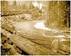
Group of men standing on pile of massive fir trees from the Chilliwack River Valley ready for yarding, Vedder Logging Company, ca. 1935. 1996 5 4.
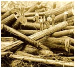
Chilliwack River - modern, 2000
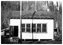
Side view of the Chilliwack River School building, ca. 1930s. P7173
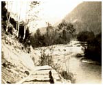
Temporary cribbing replaces road wiped out by spring runoff of the Chilliwack River, ca. 1932. P7183.