
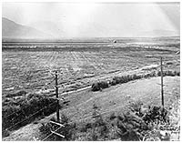
Sumas prairie following drainage of lake, with British Columbia Electric Railway line in foreground, late 1920s. P1474
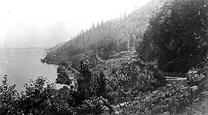
Vedder Mountain, with Sumas Lake and British Columbia Electric Railway line along lakeshore, ca. 1915. P1481

|
||||||||
| Museum Archives Exhibits Education History Links Site Index | ||||||||
| The Land : Draining the Lake | ||||||||
| The Land | The largest single flood control measure to take place in the Fraser Valley was the draining of Sumas Lake. This 10,000 acre lake, that swelled to 30,000 acres during spring flood periods, stretched across the Valley. The Chilliwack/Vedder River system and other rivers flowing in from Washington State fed it. In the early 1920s engineer Fred Sinclair developed a plan to drain the lake. By 1924, the Vedder River was diverted into the Vedder Canal, and water from the lake drained into the Sumas River and Sumas Drainage Canal, and was pumped over the dykes into the Fraser River. Habitat for fish and waterfowl was destroyed in creating this additional farmland. | |||||||
|
|
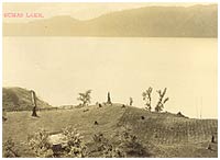
Overhead
view of Sumas Lake as seen from Majuba Hill, ca. 1910. P1479
Sumas prairie following drainage of lake, with British Columbia Electric Railway line in foreground, late 1920s. P1474 Vedder Mountain, with Sumas Lake and British Columbia Electric Railway line along lakeshore, ca. 1915. P1481 |
||||||
|
|
||||||||
|
||||||||
Museum Archives Exhibits Education History Links Site Index