America by Ortelius, 1570 - Exploration - Canada at Scale: Maps of our History - Exhibitions - Library and Archives Canada
 Library and Archive Canada - Bibliothèque et Archives Canada Français | Help     Canada  
 Home > Browse Selected Topics > Canada at Scale > Exploration
  Important Notices  
Exploration, colonization and development

GO

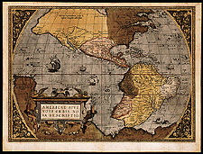
America by Ortelius, 1570

This is perhaps the most famous map of America published in the sixteenth century. It gives a good idea of the Atlantic coast of Canada and the St. Lawrence Valley.

Ortelius produced the first atlas in history, although the word "atlas" was not used in this way until Mercator first did so in 1595.

Catalogue entry:
Ortelius, Abraham, 1527-1598.
Americae sive novi orbis, nova descriptio. — Scale [ca. 1:42 500 000 at equator]. — [Antwerpiae : Ortelius, 1570]. — 1 map : hand col. ; 36 x 48 cm, on sheet 41 x 54 cm. — Plate 1, state 2. — From atlas: Ortelius, Abraham, 1527-1598. Theatrum orbis terrarum. [1570]. —

Ref. No.: NMC 027720

n027720k


Previous   Next Return to Canada at Scale