Champlain’s map, 1632 - Exploration - Canada at Scale: Maps of our History - Exhibitions - Library and Archives Canada
 Library and Archive Canada - Bibliothèque et Archives Canada Français | Help     Canada  
 Home > Browse Selected Topics > Canada at Scale > Exploration
  Important Notices  
Exploration, colonization and development

GO

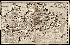
Champlain’s map, 1632

This is a consolidation of what was known about New France at the time. The explorer covered a good portion of the territory shown on the map and also relied heavily on what he was told by the Native people.

The results of European exploration west of Montreal are shown for the first time.

Catalogue entry:
Champlain, Samuel de, 1567-1635.
Carte de la Nouvelle France : augmentee depuis la derniere, servant a la navigation faicte en son vray meridien / par le Sr. de Champlain ... — Scale [ca. 1:5 700 000]. — [Paris] : Faicte ... par le sieur Champlain, 1632. — 1 map ; 52 x 85 cm, on sheet 57 x 91 cm. — Accompanies an edition of his: Les voyages de la Nouvelle France occidentale, dicte Canada ... A Paris, 1632. —

Ref. No.: NMC 051970


n051970k


Previous   Next Return to Canada at Scale