Newfoundland, 1775 - Exploration - Canada at Scale: Maps of our History - Exhibitions - Library and Archives Canada
 Library and Archive Canada - Bibliothèque et Archives Canada Français | Help     Canada  
 Home > Browse Selected Topics > Canada at Scale > Exploration
  Important Notices  
Exploration, colonization and development

GO

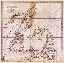
Newfoundland, 1775

James Cook, William Parker and Michael Lane carried out the first detailed survey of the coast of Newfoundland and Labrador between 1762 and 1767. Cook was one of three English hydrographers — the others were J.F.W. DesBarres and Samuel Holland — who produced accurate maps of the North Atlantic coast of the British Empire in America.

Catalogue entry:
Cook, James, 1728-1779.
A general chart of the island of Newfoundland with the rocks & soundings / drawn from surveys ... by James Cook and Michael Lane surveyors and others. — Scale [ca. 1:280 000]. — London : Printed for Robt. Sayer & Jno. Bennett [by] Thomas Jefferys, 1775. — 1 map : hand col. ; 53 x 55 cm, on sheet 62 x 73 cm. —

Ref. No.: NMC 052302

n052302k

Previous   Next Return to Canada at Scale