Newfoundland, 1773 - Exploration - Canada at Scale: Maps of our History - Exhibitions - Library and Archives Canada
 Library and Archive Canada - Bibliothèque et Archives Canada Français | Help     Canada  
 Home > Browse Selected Topics > Canada at Scale > Exploration
  Important Notices  
Exploration, colonization and development

GO

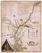
Map of the Exploits River, Newfoundland, and Beothuk villages along the riverbank, 1773

This is the map which accompanied the report written by John Cartwright, a magistrate in Newfoundland from 1768 to 1773, on the intolerable situation of Newfoundland’s Native populations. The map contains information on the now-extinct Beothuk people and shows the location of their villages and the fences they built in order to catch caribou.

Catalogue entry:
Cartwright, John, 1740-1824.
A sketch of the River Exploits and the east end of Lieutenant’s Lake in Newfoundland. — Scale indeterminable. — [1768]. — 1 map : ms., col. ; 39 x 31 cm. — From: Remarks on the situation of the Red Indians, natives of Newfoundland ... together with such descriptions as are necessary to the explanation of the sketch of country they inhabit, taken on the spot in the year 1768. 13th Jan. 1773. (Manuscript Division: MG23 A1(1), vol. 3). —

Ref. No.: NMC 000027

n000027k


Previous   Next Return to Canada at Scale