Chart of the northeastern coast of Nova Scotia, 1779 - Exploration - Canada at Scale: Maps of our History - Exhibitions - Library and Archives Canada
 Library and Archive Canada - Bibliothèque et Archives Canada Français | Help     Canada  
 Home > Browse Selected Topics > Canada at Scale > Exploration
  Important Notices  
Exploration, colonization and development

GO

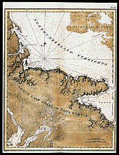
Chart of the northeastern coast of Nova Scotia, 1779

The Atlantic Neptune contains mostly charts of the coast of Nova Scotia, but there are also charts of other stretches of the Gulf of St. Lawrence coastline. The charts were published in London between 1777 and 1781.

Catalogue entry:
Des Barres, Joseph F.W. (Joseph Frederick Wallet), 1722-1824.
[North east coast of Nova Scotia]. — Scale [ca. 1:145 000]. — [London] : Publish’d ... by J.F.W. DesBarres ..., Feb. 22, 1779. — 1 map : hand col. ; 74 x 60 cm, on sheet 83 x 62 cm. —

Ref. No.: NMC 028428

n028428k


Previous   Next Return to Canada at Scale