The St. Lawrence by Nicolas Bellin, ca. 1752 - Exploration - Canada at Scale: Maps of our History - Exhibitions - Library and Archives Canada
 Library and Archive Canada - Bibliothèque et Archives Canada Français | Help     Canada  
 Home > Browse Selected Topics > Canada at Scale > Exploration
  Important Notices  
Exploration, colonization and development

GO

n017780-1 n017780-2 n017780-3

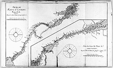
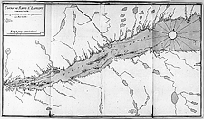
The St. Lawrence by Nicolas Bellin, ca. 1752

The St. Lawrence River was New France’s main artery, its link to the ocean, the Great Lakes and beyond to the west and Louisiana.

Three-sheet manuscript map

Catalogue entry:
Bellin, Jacques Nicolas, 1703-1772.
Cours du fleuve St. Laurent. — Scale [ca. 1:337 800]. —[ca. 1752]. — 1 map on 3 sheets : ms., col. ; sheets 58 x 100 cm or smaller. — In Cartes de la Nouvelle-France ou Canada. 1752. —

Ref. Nos.: NMC 017780-1, NMC 017780-2, NMC 017780-3


Previous   Next
Return to Canada at Scale