Murray’s map, sheet Em, Quebec City region, 1761 - Exploration - Canada at Scale: Maps of our History - Exhibitions - Library and Archives Canada
 Library and Archive Canada - Bibliothèque et Archives Canada Français | Help     Canada  
 Home > Browse Selected Topics > Canada at Scale > Exploration
  Important Notices  
Exploration, colonization and development

GO

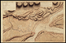
Murray’s map, sheet Em, Quebec City region, 1761

Murray’s map, named after the first British governor of the Province of Quebec, gives a detailed description of the St. Lawrence valley. It contains all the information needed to identify the riches of the new colony and ensure the colony’s defence.

Catalogue entry:
[Town and environs of Quebec]. — Scale [1:24 000]. — [1761]. — 1 map : ms., col. ; 62 x 95 cm, on sheet 65 x 100 cm. — In Plan of Canada or the Province of Quebec from the uppermost settlements to the Island of Coudre as surveyed by order of His Most Excellent Governor Murray on the year 1760, 61 & 62. [Sheet 33 (Em)]. —

Ref. No.: NMC 135067

n135067k

Previous   Next Return to Canada at Scale