Hochelaga (Montreal), 1565 - Exploration - Canada at Scale: Maps of our History - Exhibitions - Library and Archives Canada
 Library and Archive Canada - Bibliothèque et Archives Canada Français | Help     Canada  
 Home > Browse Selected Topics > Canada at Scale > Exploration
  Important Notices  
Exploration, colonization and development

GO

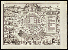
Hochelaga (Montreal), 1565

Jacques Cartier visited this Iroquois settlement in 1535 and described it in the account of his second trip to Canada. This woodcut engraving was published by Ramusio in Venice. It was the first printed map of a settlement in North America. Hochelaga may have been located atop Mount Royal.

Catalogue entry:
Ramusio, Giovanni Battista, 1485-1557.
La terra de Hochelaga nella Nova Francia. — Scale indeterminable. — [Venice : Giunti, between 1556 and 1606]. — 1 map : woodcut ; 27 x 37 cm, on sheet 31 x 43 cm. — Attributed by some to cartographer Giocomo de Gastaldi. — From atlas: Navigationi et viaggi. Vol. 3, p. 446-447. —

Ref. No.: NMC 001908

n001908k

Previous   Next Return to Canada at Scale