Part of Montreal, 1822 - Exploration - Canada at Scale: Maps of our History - Exhibitions - Library and Archives Canada
 Library and Archive Canada - Bibliothèque et Archives Canada Français | Help     Canada  
 Home > Browse Selected Topics > Canada at Scale > Exploration
  Important Notices  
Exploration, colonization and development

GO

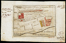
Part of Montreal, 1822

This is one of the very first known maps printed in Canada. Commercial lithography first appeared in Canada in the 1830s, but this map may have been printed by the military and government presses in Quebec City. The engraver, Bennet, also engraved other maps.

Catalogue entry:
Great Britain. Army. Corps of Royal Engineers.
Proposed distribution of lots to be sold on & near the Citadel Hill Montreal / E. Bennett, Scd. — Scale [ca. 1:1 890]. — Quebec : Commanding Royal Engineers’ Office, Jany. 10th 1822. — 1 map : hand col. ; 19 x 27 cm, on sheet 26 x 41 cm. —

Ref. No.: NMC 001517

n001517k


Previous   Next Return to Canada at Scale