Bird’s-eye view of Ottawa by Brosius, 1876 - Exploration - Canada at Scale: Maps of our History - Exhibitions - Library and Archives Canada
 Library and Archive Canada - Bibliothèque et Archives Canada Français | Help     Canada  
 Home > Browse Selected Topics > Canada at Scale > Exploration
  Important Notices  
Exploration, colonization and development

GO

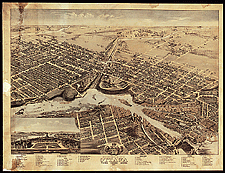
Bird’s-eye view of Ottawa by Brosius, 1876

This was another very popular type of map from the 1850s to the 1920s. The view shows the whole town as if seen from the air. This view of the new capital reflects its beauty and dynamic force. Many towns in Canada, big or small, were depicted in this form.

Catalogue entry:
Brosius, H.
Bird’s eye view of the city of Ottawa, Province, Ontario, Canada / drawn by Herm. Brosius. — Scale varies. — [Chicago] : Chas. Shober & Co. : Chicago Litho. Co., 1876. — 1 view : col. ; 61 x 87 cm, on sheet 71 x 93 cm. —

Ref. No.: NMC 021081

n021081k


Previous   Next Return to Canada at Scale