North America by Arrowsmith, 1802 - Exploration - Canada at Scale: Maps of our History - Exhibitions - Library and Archives Canada
 Library and Archive Canada - Bibliothèque et Archives Canada Français | Help     Canada  
 Home > Browse Selected Topics > Canada at Scale > Exploration
  Important Notices  
Exploration, colonization and development

GO

n019687-1kn019687-2k

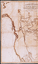
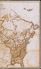
North America by Arrowsmith, 1802

This map (first edition in 1795, last edition in 1850) was the first to give a detailed view of the western and northern parts of the continent. It contains information reported by recent expeditions to Canada. The western portion of the United States was updated following the expedition by Lewis and Clark (1803-1806). The Ac Ko Mok Ki indigenous map and other data provided by the Native peoples enabled the mapmaker to describe vast regions.

Catalogue entry:
Arrowsmith, Aaron, 1750-1823.
A map exhibiting all the new discoveries in the interior parts of North America / inscribed by ... A. Arrowsmith. — Additions to 1802. — Scale [ca. 1: 4 500 000]. — London : A. Arrowsmith, No. 24 Rathbone Place, [1802]. — 1 map ; hand col. ; 124 x 144 cm, on sheets 126 x 73 cm each. —

Ref. Nos.: NMC 019687-1, 019687-2


Previous   Next

Return to Canada at Scale