British Columbia, 1871 - Exploration - Canada at Scale: Maps of our History - Exhibitions - Library and Archives Canada
 Library and Archive Canada - Bibliothèque et Archives Canada Français | Help     Canada  
 Home > Browse Selected Topics > Canada at Scale > Exploration
  Important Notices  
Exploration, colonization and development

GO

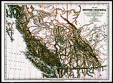
British Columbia, 1871

The well known "Trutch map" is named after Joseph William Trutch, Chief Commissioner of Lands and Works of the colony of British Columbia from 1864 to 1871 and the first lieutenant governor of the province from 1871 to 1876. He fought hard to bring British Columbia into Confederation. The map is a detailed summary of the geographical and economical knowlewdge about the then latest new province.

Catalogue entry:
British Columbia. Dept. of Lands and Works.

Map of British Columbia : to the 56th parallel north latitude / compiled and drawn at the Lands and Works Office, Victoria, B.C. under the direction of ... J.W. Trutch ... 1871 ; J.B. Launders, draughtsman ... May 9th 1870. — Additions to Jan. 1871. — Scale 1:1 584 000. — London : Edward Stanford, Oct. 18th, 1871. — 1 map ; 63 x 88 cm, on sheet 70 x 96 cm. —

Ref. No.: NMC 017470

n017470k.


Previous   Next Return to Canada at Scale