Map of the North Pole, 1595 - Exploration - Canada at Scale: Maps of our History - Exhibitions - Library and Archives Canada
 Library and Archive Canada - Bibliothèque et Archives Canada Français | Help     Canada  
 Home > Browse Selected Topics > Canada at Scale > Exploration
  Important Notices  
Exploration, colonization and development

GO

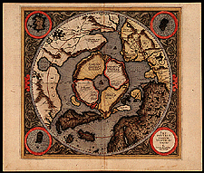
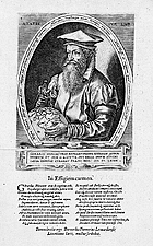
Map of the North Pole, 1595

The challenge was to understand the geography of the Arctic  --  that was the explanation Mercator offered. This map based on recent exploration data also includes mythological concepts and is like an eye with the North Pole as the pupil. Mercator’s portrait (1574) shows him holding a globe with North America and the Arctic in clear view, a reflection of his interest in the northern New World.

Catalogue entry:
Mercator, Gerardus, 1512-1594.
Septentrionalium terrarum descriptio / per Gerardum Mercatorem. — Scale [ca. 1:20 000 000]. — [Rupella] : Typographus sumptibus haeredum Gerardi Mercatris Rupelmundi, 1595]. — 1 map : hand col. ; 33.5 cm in diam., image 37 x 39 cm. — From: Atlas sive cosmographicae meditationes de fabrica mundi et fabricati figura.

Ref. No.: NMC 016097


Hogenberg, Franz, d. 1590?
Gerardi Mercatoris Rvpelmvndant effigiem ... / depingi cvrabat Franc. Hog. — 1574. — 1 print : engraved, b&w ; 20 x 15 cm. — In Mercator, Gerardus. Atlas sive cosmographicae meditationes de fabrica mvndi et fabricata figvra. Dvsseldorpii : Excudebat Albertus Busius, 1595. Frontispiece.

Ref. No.: C 146376


n016097k

c146376

Previous   Next Return to Canada at Scale