Hudson Bay region, 1612 - Exploration - Canada at Scale: Maps of our History - Exhibitions - Library and Archives Canada
 Library and Archive Canada - Bibliothèque et Archives Canada Français | Help     Canada  
 Home > Browse Selected Topics > Canada at Scale > Exploration
  Important Notices  
Exploration, colonization and development

GO

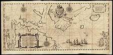
Hudson Bay region, 1612

Henry Hudson arrived in Arctic waters in 1610 determined to find the Northwest Passage. He explored Hudson Bay and the mouth of the Bay. His crew mutinied and abandoned him in 1611 and returned to Europe. This map by Dutch cartographer Gerritsz is based on Hudson’s discoveries. Hudson’s explorations were a major factor in subsequent English domination in the Arctic.

Catalogue entry:
Gerritsz, Hessel, 1581?-1632.
Tabvla navtica qua repraesentantur orae maritimae meatus, ac freta, noviter a I Hudsona Anglo ad caurum supra Novam Franciam indagata anno 1612. — Scale [ca. 1:11 000 000]. — [Amsterdam : Hessel Gerritsz, 1613]. — 1 map : 24 x 55 cm, on sheet 29 x 58 cm. — From: Descriptio ac delineatio geographica detectionis freti ... —

Ref. No.: NMC 019228

n019228k

Previous   Next Return to Canada at Scale