Exploring the Arctic, 1904 - Exploration - Canada at Scale: Maps of our History - Exhibitions - Library and Archives Canada
 Library and Archive Canada - Bibliothèque et Archives Canada Français | Help     Canada  
 Home > Browse Selected Topics > Canada at Scale > Exploration
  Important Notices  
Exploration, colonization and development

GO

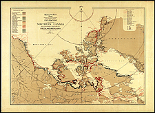
Exploring the Arctic, 1904

Maps showing all the discoveries in the Arctic were produced in the 1850s. This 1904 map was published by the Government of Canada at a time when the government wanted to assert its sovereignty over the region. Captain Bernier led government expeditions into these areas between 1904 and 1911.

Catalogue entry:
Canada. Dept. of the Interior.
Explorations in northern Canada and adjacent portions of Greenland and Alaska / James White. — Scale [ca. 1:4 700 000]. — [Ottawa] : Dept. of the Interior, 1904. — 1 map : col. ; 65 x 89 cm, on sheet 74 x 104 cm. —

Ref. No.: NMC 017629

n017629k


Previous   Next Return to Canada at Scale