|
|
Maps17th CenturyIn 1603, Samuel de Champlain arrived at the mouth of the Saguenay River with the trader Aymar de Chaste. His orders were to "...see the country and what the colonizers might accomplish there" and to "give the King [Henri IV] a faithful report thereon." (Biggar 1929, 315) France had decided to establish a colony in Canada. In his first summer Champlain resolved on the following ways in which Canada could be explored:
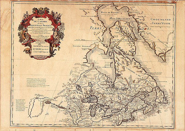
Between 1603 and 1616 Champlain explored and mapped eastern Canada from the St. Lawrence Valley through Georgian Bay and Lake Ontario, and along the Atlantic coast to Cape Cod. By the end of his life (1635) he had produced five small-scale maps and twenty-three detailed plans of harbours and settlements such as those at Tadoussac. Among the small-scale maps, that of 1612 contains the first rendering of Lake Ontario and Niagara Falls, both based on Native mapping. While Champlain was busy on the Atlantic Coast, the English renewed their efforts to find a northwest passage. Interest focussed on the 'furious over fall' (currents) emanating from a strait first noticed by John Davis and marked on Wright's (1599) map. In 1610, Henry Hudson managed to penetrate this ice-choked strait to a huge bay, both of which were later named after him. The charts brought back by the survivors of this expedition were engraved and published in 1612 by Gerritsz. Hudson's successors Button (1612-13) and Bylot with Baffin (1615) contributed to Briggs's (1625) chart, the first modern outline of Hudson Bay. Finally, the voyages of Luke Foxe (1631) and Thomas James (1631-32) laid to rest, for a while, the notion of finding a practical northwest passage. Their maps also included the northern findings of Baffin (1616). With Thornton's 1685 chart of the Bay, the Hudson's Bay Company finally improved on the earlier versions.
After Champlain's death in the 1670s, the major explorers and mapmakers were the Jesuits. In order to promote religious missions, French explorers other than the Jesuits -- and those who worked for them -- were barred from the interior west of Montreal after 1632. The aim of this was to let Jesuits operate without secular interference and to keep Frenchmen near the St. Lawrence where they could farm and protect the colony. The ban was gradually modified but was not entirely lifted until 1681. By the end of the 1640s the Jesuits had mapped the Huron country, and furnished the information incorporated by the maps of Sanson, Bressani and Du Creux. The beautiful Bressani map contains the only accurate 17th century pictures of Huron and Iroquois life and the earliest picture of the martyrdom of Fathers Brébeuf and Lalemant (1649). Further Jesuit mapping led to the first map of Lake Superior (1672) by Fathers Allouez and Dablon, the first map of the Missippi (1673) by Father Marquette and good maps of the Iroquois country (1688) by Father Raffeix.
In 1681, the French government officially opened the Canadian interior to fur traders through a licensing system. The information brought back by men such as Jolliet, Peré, La Salle and others was compiled into maps by Canada's first official cartographer, Jean-Baptiste-Louis Franquelin, and sent to the Ministry of the Marine in France, where professional cartographers at the court had access to them. The maps by the royal geographers Coronelli (1688-89) and Delisle (1700 and 1703) best sum up the 17th century mapping of Canada. Surveying during the 17th century was confined mainly to the St. Lawrence Valley. Cadastral maps showing property boundaries commenced with the first survey of the original seigneuries in 1641 by Bourdon. The St. Lawrence River was charted for shipping by Louis Jolliet and Franquelin in 1685, but much more expertly by Jean Deshayes in 1685-86. This chart was put into print in 1702 by de Fer and became the standard chart of the river until the British surveys after 1760. SIGNIFICANT MAPS OF THE PERIOD
|

![Map: ["Port Royal"], by Samuel de Champlain, 1613](../obj/h24/f1/nlc001137-v6.jpg)

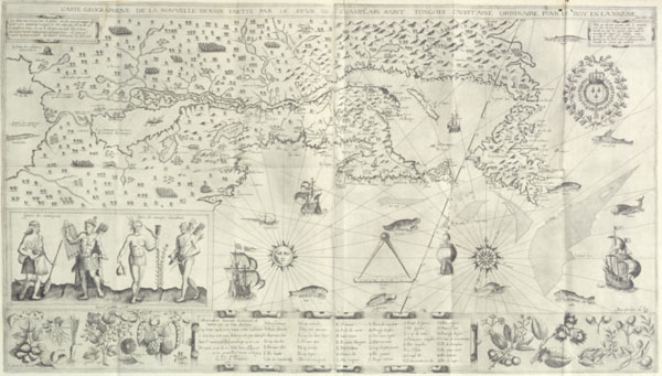
![Map: "Lac superieur
," by the Jesuits Dablon and Allouez, [1672]](../../data2.collectionscanada.gc.ca/nmc/n0006407.jpg)